1940s Maps of Chalk Level, Missouri
Explore 2 historic maps of Chalk Level from the 1940s. These maps offer a rare glimpse into what life looked like during the 1940s — showing old roads, neighborhoods, homes, and landmarks that have changed or disappeared over time.
Whether you're researching your family's past, planning a metal detecting trip, or studying how Chalk Level's landscape evolved across the 1940s, these high-resolution maps are a powerful tool for exploring the history of this region.
- Focus on a specific era: All maps on this page are from the 1940s, giving you a focused view of this time period.
- See what’s changed: Compare century-old streets, trails, and buildings to today's modern landscape using overlays and satellite layers.
- Research with precision: Use these maps for genealogy, historical research, land use analysis, or educational projects.
- View, download, or print: Maps are fully viewable online in high resolution, and can be downloaded or printed for your own records.
Start exploring Chalk Level's history through authentic maps from the 1940s. This is your window into the past.
Chalk Level, MO maps
(2)- 1940 Map of Monegaw Springs
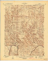 1940 Monegaw Springs1940 Print · USGSSt. Clair County's rural townships are shown here in the late 1930s, documenting a landscape of small farmstead schools and country chapels. Researchers can trace family history at Benton Green Cem or locate the old Washington Sch and Monegaw Springs.2 unique versions available
 - 1947 Map of Jefferson City, 1949 Print
 1947 Jefferson City1949 Print · USGSCentral Missouri and the northern Ozarks come into focus in this late 1940s survey of the river-and-rail landscape. Genealogists and historians can trace the growth of Jefferson City and Sedalia or locate family roots near Bagnell Dam and the Lake of the Ozarks.
End of results
Showing maps 1-2 of 2
Top cities near Chalk Level
- El Dorado Springs historical maps
- Appleton City historical maps
- Osceola historical maps
- Lowry City historical maps
- Deepwater historical maps
- Montrose historical maps
See more
Frequently asked questions
- What are the different types of historical maps available for Chalk Level?
- What is the oldest map of Chalk Level?
- Where can I purchase historical maps of Chalk Level for my home or office?
- Where can I download high-res historical maps of Chalk Level?
- Are there historical topographic maps available for Chalk Level?
- Is there historical aerial imagery available for Chalk Level?
- Where are historical maps of Chalk Level sourced from?