1900s (20th Century) Maps of Collins, Missouri
Explore 12 historic maps of Collins from the 1900s (20th Century). These maps offer a rare glimpse into what life looked like during the 1900s — showing old roads, neighborhoods, homes, and landmarks that have changed or disappeared over time.
Whether you're researching your family's past, planning a metal detecting trip, or studying how Collins's landscape evolved across the 1900s, these high-resolution maps are a powerful tool for exploring the history of this region.
- Focus on a specific era: All maps on this page are from the 1900s, giving you a focused view of this time period.
- See what’s changed: Compare century-old streets, trails, and buildings to today's modern landscape using overlays and satellite layers.
- Research with precision: Use these maps for genealogy, historical research, land use analysis, or educational projects.
- View, download, or print: Maps are fully viewable online in high resolution, and can be downloaded or printed for your own records.
Start exploring Collins's history through authentic maps from the 1900s. This is your window into the past.
Collins, MO maps
(12)- 1938 Map of Vista, 1952 Print
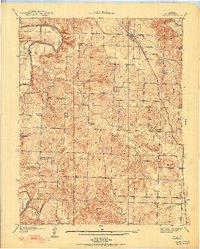 1938 Vista1952 Print · USGSSt. Clair County's rural townships are captured in the late 1930s, showing a landscape of small family farms and community hubs before major modernization. Researchers can trace the path of the St Louis-San Francisco railroad or locate family burial sites at Doyal Cem and Allen Cem.2 unique versions available
 - 1940 Map of Vista
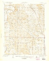 1940 Vista1940 Print · USGSSt. Clair County was a landscape of small school districts and railroad stops just before the 1940s. Genealogists can trace family footprints through sites like Doyal Cem, Tower Grove Sch, and the St Louis-San Francisco rail line through Vista.2 unique versions available
 - 1940 Map of Weaubleau, 1954 Print
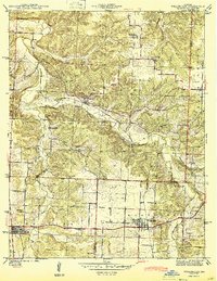
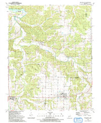
 1940 Weaubleau1954 Print · USGSThe St. Clair and Hickory county line area comes into focus in the 1940s, showing a landscape of rail-linked towns and local school districts. Trace family roots at Robinson Cem or explore the old routes through Gerster, Collins, and Weaubleau.2 unique versions available
 - 1944 Map of Humansville
 1944 Humansville1944 Print · USGSNear the intersection of three counties in the mid-1940s, this area centered on a thriving rail and agricultural landscape. Local historians can trace family roots through numerous country schoolhouses like Elm Grove Sch and cemeteries such as Richardson Cem.3 unique versions available
 - 1944 Map of Weaubleau
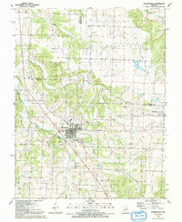
 1944 Weaubleau1944 Print · USGSHickory and St. Clair Counties come into focus during the early 1940s as the railroad and rural school districts defined local life. Researchers can trace family-named landmarks and early homesteads near Weaubleau, Gerster, and Robinson Cem.2 unique versions available
 - 1954 Map of Springfield
 1954 Springfield1954 Print · USGSThe Missouri Ozarks are captured here during the post-war era, showing the expansion of Springfield and the surrounding river valleys. Genealogists and historians can trace local landmarks like Mount Comfort Cemetery and the Fort Leonard Wood military grounds.6 unique versions available
 - 1958 Map of Springfield
 1958 Springfield1958 Print · USGSThe Missouri Ozarks are captured during the mid-century era of growth, centered on the bustling hub of Springfield. Genealogists and historians can trace family roots through numerous landmarks like Ebenezer Church, Stockton Cem, and the various county courthouses.
 - 1959 Map of Springfield
 1959 Springfield1959 Print · USGSThe Missouri Ozarks are captured here during a decade of postwar growth and increasing highway connectivity. Researchers can trace the legacy of the St Louis-San Francisco RR and locate early sites in Springfield, Lebanon, and Mountain Grove.
 - 1984 Map of Bolivar
 1984 Bolivar1984 Print · USGSWestern Missouri in the mid-eighties shows a landscape shaped by large-scale water management and rail commerce. Genealogists and historians can trace the development of towns like Bolivar and El Dorado Springs alongside the massive Stockton Lake.
 - 1991 Map of Vista
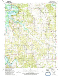 1991 Vista1991 Print · USGSIn the early 1990s, this area of St. Clair County shows a rural landscape shaped by the Harry S Truman Reservoir and the Sac River. Researchers can trace numerous family burial sites like Macedonia Cem and Roberts Cem or locate the Old Railroad Grade near Vista.
 - 1991 Map of Weaubleau
 1991 Weaubleau1991 Print · USGSLife along the Hickory and St. Clair county line in the early nineties centered on small agricultural hubs and creek valleys. Genealogists and historians can trace the Old Railroad Grade past Gerster or locate the Robinson Cem and Kings Prairie Ch.
 - 1991 Map of Humansville
 1991 Humansville1991 Print · USGSThe Polk County countryside near Humansville is shown here in the early nineties, centered on a landscape of prairie and creek valleys. Researchers can trace family history through numerous local sites like Flemington Cem, Rondo, and the Old Railroad Grade.
End of results
Showing maps 1-12 of 12
Top cities near Collins
- Stockton historical maps
- Humansville historical maps
- Osceola historical maps
- Weaubleau historical maps
- Wheatland historical maps
- Flemington historical maps
See more
Frequently asked questions
- What are the different types of historical maps available for Collins?
- What is the oldest map of Collins?
- Where can I purchase historical maps of Collins for my home or office?
- Where can I download high-res historical maps of Collins?
- Are there historical topographic maps available for Collins?
- Is there historical aerial imagery available for Collins?
- Where are historical maps of Collins sourced from?