1940s Maps of Lowry City, Missouri
Explore 3 historic maps of Lowry City from the 1940s. These maps offer a rare glimpse into what life looked like during the 1940s — showing old roads, neighborhoods, homes, and landmarks that have changed or disappeared over time.
Whether you're researching your family's past, planning a metal detecting trip, or studying how Lowry City's landscape evolved across the 1940s, these high-resolution maps are a powerful tool for exploring the history of this region.
- Focus on a specific era: All maps on this page are from the 1940s, giving you a focused view of this time period.
- See what’s changed: Compare century-old streets, trails, and buildings to today's modern landscape using overlays and satellite layers.
- Research with precision: Use these maps for genealogy, historical research, land use analysis, or educational projects.
- View, download, or print: Maps are fully viewable online in high resolution, and can be downloaded or printed for your own records.
Start exploring Lowry City's history through authentic maps from the 1940s. This is your window into the past.
Lowry City, MO maps
(3)- 1941 Map of Lowry City, 1965 Print
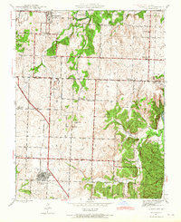 1941 Lowry City1965 Print · USGSLowry City and Brownington are captured at the start of the 1940s, showing a Missouri landscape defined by the St Louis San Francisco RR and family farms. Genealogists can locate numerous rural schools and landmarks like Diamond Point Sch, Mount Zion Ch, and Park Grove Cem.3 unique versions available
 - 1945 Map of Lowry City
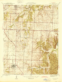 1945 Lowry City1945 Print · USGSMissouri's rural heartland comes alive in the mid-forties, showing the dense network of schools and churches between the Grand River and the rail lines. Genealogists can trace family roots through several landmarks like Denny Cem, Park Grove Ch, and the St Louis San Francisco railroad.
 - 1947 Map of Jefferson City, 1949 Print
 1947 Jefferson City1949 Print · USGSCentral Missouri and the northern Ozarks come into focus in this late 1940s survey of the river-and-rail landscape. Genealogists and historians can trace the growth of Jefferson City and Sedalia or locate family roots near Bagnell Dam and the Lake of the Ozarks.
End of results
Showing maps 1-3 of 3
Top cities near Lowry City
- Clinton historical maps
- Leesville historical maps
- Osceola historical maps
- Deepwater historical maps
- Collins historical maps
- Brownington historical maps
See more
Frequently asked questions
- What are the different types of historical maps available for Lowry City?
- What is the oldest map of Lowry City?
- Where can I purchase historical maps of Lowry City for my home or office?
- Where can I download high-res historical maps of Lowry City?
- Are there historical topographic maps available for Lowry City?
- Is there historical aerial imagery available for Lowry City?
- Where are historical maps of Lowry City sourced from?