1930s Maps of Asherville, Missouri
Explore 2 historic maps of Asherville from the 1930s. These maps offer a rare glimpse into what life looked like during the 1930s — showing old roads, neighborhoods, homes, and landmarks that have changed or disappeared over time.
Whether you're researching your family's past, planning a metal detecting trip, or studying how Asherville's landscape evolved across the 1930s, these high-resolution maps are a powerful tool for exploring the history of this region.
- Focus on a specific era: All maps on this page are from the 1930s, giving you a focused view of this time period.
- See what’s changed: Compare century-old streets, trails, and buildings to today's modern landscape using overlays and satellite layers.
- Research with precision: Use these maps for genealogy, historical research, land use analysis, or educational projects.
- View, download, or print: Maps are fully viewable online in high resolution, and can be downloaded or printed for your own records.
Start exploring Asherville's history through authentic maps from the 1930s. This is your window into the past.
Asherville, MO maps
(2)- 1934 Map of Puxico
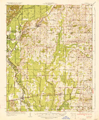 1934 Puxico1934 Print · USGSThe Missouri Bootheel comes into focus during the 1930s as drainage projects and rail lines reshape the swampy lowlands. Genealogists can locate dozens of country schools like Wilkerson Sch and Zoll Sch, or trace the tracks of the St Louis San Francisco through Puxico.2 unique versions available
 - 1939 Map of Puxico, 1942 Print
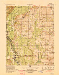 1939 Puxico1942 Print · USGSSoutheast Missouri's bootheel region comes to life in the late 1930s, showing a landscape defined by extensive drainage projects and burgeoning rail towns. Trace the locations of rural schoolhouses like Edmundson Sch and lost junctions along the St Louis - San Francisco Ry.
End of results
Showing maps 1-2 of 2
Top cities near Asherville
- Poplar Bluff historical maps
- Dexter historical maps
- Bernie historical maps
- Puxico historical maps
- Fisk historical maps
- Dudley historical maps
Frequently asked questions
- What are the different types of historical maps available for Asherville?
- What is the oldest map of Asherville?
- Where can I purchase historical maps of Asherville for my home or office?
- Where can I download high-res historical maps of Asherville?
- Are there historical topographic maps available for Asherville?
- Is there historical aerial imagery available for Asherville?
- Where are historical maps of Asherville sourced from?