
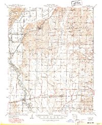
1934 Map of Puxico
USGS Topo · Published 1934About this map
Puxico stands as the primary hub of this 1930s landscape, positioned at the junction of the St Louis San Francisco railroad and a network of drainage ditches that redefined the Missouri Bootheel. The map reveals an area in transition, where the heavy wetlands of The Glades Swamp and Bee Tree Cypress Spreads meet the rising elevations of Acorn Ridge and Hodge Hill. This era is marked by a dense patchwork of small rural schools, such as Rockwell Sch, Shoemaker Sch, and Edmundson Sch, which served the scattered farming settlements before the consolidation of the mid-20th century.
Find a feature on this map
79 named features on this map. Tap any name to fly to it.
Don’t see what you’re looking for? This feature index may not catch every label — zoom into the map to look around manually.
Map Details
Editions of this 1934 Puxico Map
2 editions found
Other maps of this area

1934 · Greenville
USGS Topo · 1:62,500

1934 · Bloomfield
USGS Topo · 1:62,500

1934 · Advance
USGS Topo · 1:62,500

1935 · Poplar Bluff
USGS Topo · 1:62,500

1935 · Zalma
USGS Topo · 1:62,500

1935 · Harviell
USGS Topo · 1:62,500

1939 · Bloomfield
USGS Topo · 1:62,500

1939 · Greenville
USGS Topo · 1:62,500

1939 · Advance
USGS Topo · 1:62,500

1939 · Puxico
USGS Topo · 1:62,500