1930s Maps of Hunterville, Missouri
Explore 2 historic maps of Hunterville from the 1930s. These maps offer a rare glimpse into what life looked like during the 1930s — showing old roads, neighborhoods, homes, and landmarks that have changed or disappeared over time.
Whether you're researching your family's past, planning a metal detecting trip, or studying how Hunterville's landscape evolved across the 1930s, these high-resolution maps are a powerful tool for exploring the history of this region.
- Focus on a specific era: All maps on this page are from the 1930s, giving you a focused view of this time period.
- See what’s changed: Compare century-old streets, trails, and buildings to today's modern landscape using overlays and satellite layers.
- Research with precision: Use these maps for genealogy, historical research, land use analysis, or educational projects.
- View, download, or print: Maps are fully viewable online in high resolution, and can be downloaded or printed for your own records.
Start exploring Hunterville's history through authentic maps from the 1930s. This is your window into the past.
Hunterville, MO maps
(2)- 1934 Map of Bloomfield
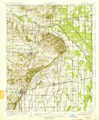 1934 Bloomfield1934 Print · USGSStoddard County in the early 1930s shows a landscape defined by industrial drainage projects and a robust network of rural schools. Genealogists can trace family footprints at Dowdy Cem or identify old community centers like Walker Ch and Philadelphia Ch.3 unique versions available
 - 1939 Map of Bloomfield
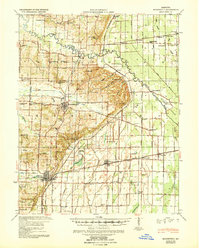 1939 Bloomfield1939 Print · USGSBefore the full consolidation of modern school districts, this 1930s landscape was dotted with local anchors like Gravel Hill Sch and Beech Grove Sch. You can trace the complex drainage networks of Ditch No 33 and Panther Creek that transformed these Missouri bottomlands near Bloomfield.
End of results
Showing maps 1-2 of 2
Top cities near Hunterville
- Sikeston historical maps
- Dexter historical maps
- Malden historical maps
- New Madrid historical maps
- Bloomfield historical maps
- Bernie historical maps
See more
Frequently asked questions
- What are the different types of historical maps available for Hunterville?
- What is the oldest map of Hunterville?
- Where can I purchase historical maps of Hunterville for my home or office?
- Where can I download high-res historical maps of Hunterville?
- Are there historical topographic maps available for Hunterville?
- Is there historical aerial imagery available for Hunterville?
- Where are historical maps of Hunterville sourced from?