1950s Maps of Stone County, Missouri
Explore 12 historic maps of Stone County from the 1950s. These maps offer a rare glimpse into what life looked like during the 1950s — showing old roads, neighborhoods, homes, and landmarks that have changed or disappeared over time.
Whether you're researching your family's past, planning a metal detecting trip, or studying how Stone County's landscape evolved across the 1950s, these high-resolution maps are a powerful tool for exploring the history of this region.
- Focus on a specific era: All maps on this page are from the 1950s, giving you a focused view of this time period.
- See what’s changed: Compare century-old streets, trails, and buildings to today's modern landscape using overlays and satellite layers.
- Research with precision: Use these maps for genealogy, historical research, land use analysis, or educational projects.
- View, download, or print: Maps are fully viewable online in high resolution, and can be downloaded or printed for your own records.
Start exploring Stone County's history through authentic maps from the 1950s. This is your window into the past.
Stone County, MO maps
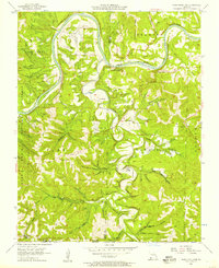
(12)- 1950 Map of Shell Knob, 1957 Print
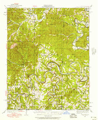 1950 Shell Knob1957 Print · USGSThe White River valley in the early 1950s retains its original character, defined by an intricate network of river fords and rural schoolhouses. Researchers can trace ancestral connections through named crossings like Cole Ford and community centers like Liberty Church or the Schreiner Ferry.3 unique versions available
 - 1950 Map of Garber, 1981 Print
 1950 Garber1981 Print · USGSThe Ozark hills transition into a recreation and heritage hub during the mid-twentieth century as the new lake levels rise. Researchers can trace the roots of local lore at Old Matt's Cabin, visit the Notch Ch, or locate the site of Marvel Cave.
 - 1954 Map of Harrison
 1954 Harrison1954 Print · USGSThe Ozarks and Boston Mountains meet during a period of massive river engineering in the mid-fifties. Researchers can trace the early shorelines of Bull Shoals Lake and Table Rock Reservoir or locate inland towns like Berryville and Harrison.
 - 1955 Map of Hurley, 1957 Print
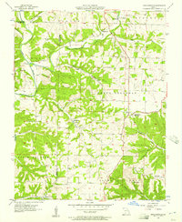
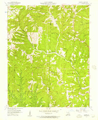
 1955 Hurley1957 Print · USGSStone and Christian Counties were characterized by small farming hamlets and river-valley crossings in the mid-fifties. Genealogists can trace family names at Wright Chapel Cem or locate old community centers like Possum Trot, Lanetown, and Union City.2 unique versions available
 - 1955 Map of Highlandville, 1957 Print
 1955 Highlandville1957 Print · USGSThe Missouri Ozarks are captured here in the mid-1950s, showing a landscape of upland ridges and deep-cut creek valleys. Genealogists can locate family burial sites like Mayberry Cem and Tory Cem or rural centers like Ponce de Leon.2 unique versions available
 - 1956 Map of Lampe, 1957 Print
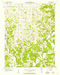
 1956 Lampe1957 Print · USGSThe Missouri Ozarks are seen here in the mid-1950s, shortly before the local river valleys were transformed by major reservoir projects. Researchers can trace ancestral locations through numerous family landmarks like Philibert Cem, Evans Cem, and the high point at Bread Tray Mountain.3 unique versions available
 - 1956 Map of Table Rock Dam, 1957 Print
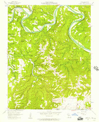
 1956 Table Rock Dam1957 Print · USGSTaney County and the White River valley are shown in the mid-fifties, precisely when Table Rock Dam was reshaping the landscape. Researchers can trace land that would soon be underwater and locate local landmarks like Oasis, Bowman Ch, and the Hollister Lookout Tower.5 unique versions available
 - 1956 Map of Garber, 1957 Print
 1956 Garber1957 Print · USGSThe Ozark hills of Taney and Stone Counties are captured here in the mid-fifties, just as the region's literary fame was fueling early tourism. Researchers can locate the legendary Old Matts Cabin, the depths of Marvel Cave, and the abandoned Garber School along the rail line.3 unique versions available
 - 1956 Map of Spokane, 1957 Print
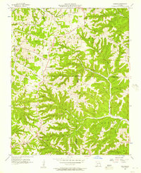 1956 Spokane1957 Print · USGSThe Ozark plateau in the mid-1950s reveals a network of ridge-top settlements and creek-bottom homesteads across Christian and Stone Counties. Local researchers can trace family landmarks like Schupbach Cem, the site of Old Spanish Cave, and the rural community of Abesville.2 unique versions available
 - 1956 Map of Reeds Spring, 1957 Print
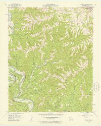 1956 Reeds Spring1957 Print · USGSStone County in the mid-fifties shows the Ozark river valleys before the major reservoir changes. Researchers can trace rural lineages through sites like Yocum Pond Cem, Stallion Sch, and local congregations at Rock Ch.2 unique versions available
 - 1956 Map of Galena, 1957 Print
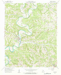 1956 Galena1957 Print · USGSThe Ozark highlands of Stone County come alive in the mid-1950s as the James River loops past the town of Galena. Genealogists and historians can trace family-named landmarks like Parsons Cem and follow the route of the Missouri Pacific railroad.2 unique versions available
 - 1958 Map of Harrison, 1973 Print
 1958 Harrison1973 Print · USGSThe Ozark and Boston Mountains appear in this mid-century survey as the great White River impoundments were reshaping the region. Researchers can trace the rail lines of the St Louis-San Francisco Ry and locate early settlements like Berryville and Gainesville.
End of results
Showing maps 1-12 of 12
Top cities of Stone County
- Kimberling City historical maps
- Crane historical maps
- Reeds Spring historical maps
- Galena historical maps
- Branson West historical maps
- McCord Bend historical maps
See more
Frequently asked questions
- What are the different types of historical maps available for Stone County?
- What is the oldest map of Stone County?
- Where can I purchase historical maps of Stone County for my home or office?
- Where can I download high-res historical maps of Stone County?
- Are there historical topographic maps available for Stone County?
- Is there historical aerial imagery available for Stone County?
- Where are historical maps of Stone County sourced from?