1990s Maps of Vernon County, Missouri
Explore 17 historic maps of Vernon County from the 1990s. These maps offer a rare glimpse into what life looked like during the 1990s — showing old roads, neighborhoods, homes, and landmarks that have changed or disappeared over time.
Whether you're researching your family's past, planning a metal detecting trip, or studying how Vernon County's landscape evolved across the 1990s, these high-resolution maps are a powerful tool for exploring the history of this region.
- Focus on a specific era: All maps on this page are from the 1990s, giving you a focused view of this time period.
- See what’s changed: Compare century-old streets, trails, and buildings to today's modern landscape using overlays and satellite layers.
- Research with precision: Use these maps for genealogy, historical research, land use analysis, or educational projects.
- View, download, or print: Maps are fully viewable online in high resolution, and can be downloaded or printed for your own records.
Start exploring Vernon County's history through authentic maps from the 1990s. This is your window into the past.
Vernon County, MO maps
(17)- 1991 Map of Papinville
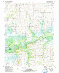 1991 Papinville1991 Print · USGSBates and Vernon counties meet at the confluence of the Osage and Marais des Cygnes rivers in the early nineties. Genealogists can locate several remote burial grounds like Flat Rock Cem and Maus Cem or trace the early footprint of Papinville.
 - 1991 Map of Hume
 1991 Hume1991 Print · USGSThe Missouri-Kansas border area near Hume is captured here during the late twentieth century, showing a landscape defined by state-line boundaries and rural heritage. Researchers can locate family sites and landmarks like Lawrence Cem, Amos, and Rocky Mound.
 - 1991 Map of Deerfield
 1991 Deerfield1991 Print · USGSThe Missouri-Kansas borderlands in the early 1990s show a landscape of rural townships and active extraction. Genealogists and researchers can trace family landmarks like Logan Cem and Clayton Ch or follow the path of the Marmaton River past Eve.
 - 1991 Map of Nevada
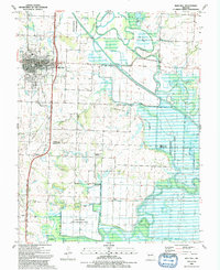
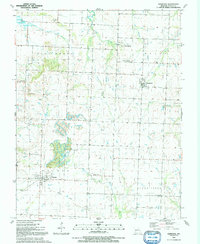
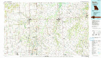
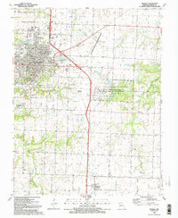 1991 Nevada1991 Print · USGSNevada and the surrounding Missouri countryside are shown in the early nineties as a blend of college town life and military heritage. Genealogists can trace family names through Marvin Chapel Cem and Moore Cem, or locate landmarks like Cottey College and Nassau Junction.2 unique versions available
 - 1991 Map of Rich Hill
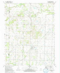
 1991 Rich Hill1991 Print · USGSBates and Vernon Counties were captured in the early nineties as a landscape of river bends and rural crossroads. Local historians can trace the foundations of Rich Hill and its surrounding communities, including Panama, Carbon Center, and the Harmony Sch site.
 - 1991 Map of Moundville
 1991 Moundville1991 Print · USGSMoundville and the western outskirts of Nevada are shown here in the early nineties as the Marmaton River bottomlands met expanding state wildlife areas. Researchers can trace rural lineages at Jewell Cem, Beckmon Cem, and Sylvan Dale Ch.
 - 1991 Map of El Dorado Springs North
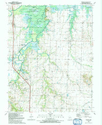
 1991 El Dorado Springs North1991 Print · USGSThe rural borderlands of Cedar and St. Clair counties are documented here in the early nineties as El Dorado Springs expanded. Genealogists and historians can locate family landmarks like Lefler Cem, Portia, and the old Railroad Grade.
 - 1991 Map of Horton
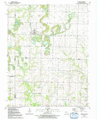
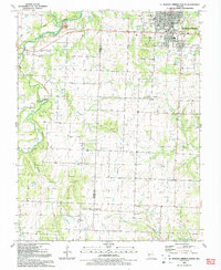
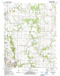
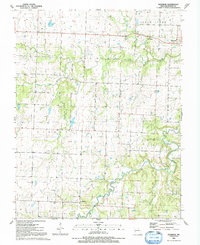
 1991 Horton1991 Print · USGSVernon County in the early nineties is defined by the winding confluence of the Marmaton and Little Osage Rivers. Genealogists and local historians can trace the rail-and-river geography of the era near Horton, Compton Junction, and the Ellis Cem.
 - 1991 Map of Harwood
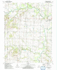
 1991 Harwood1991 Print · USGSVernon County, Missouri, is captured here in the early nineties, showcasing the rural crossroads and drainage basins of the western plains. Genealogists and local historians can trace family sites near Fair Haven, Walker, and the Old Railroad Grade.
 - 1991 Map of El Dorado Springs South
 1991 El Dorado Springs South1991 Print · USGSCedar and Vernon Counties were well-established rural communities by the early nineties, centered around agricultural hubs. Genealogists can trace family names and local landmarks through the Virgil City Cemetery, Union Hall Church, and the streets of El Dorado Springs.
 - 1991 Map of Richards
 1991 Richards1991 Print · USGSVernon County and the Kansas borderlands appear in detail in the early nineties, showing a landscape defined by the Little Osage River. Researchers can trace the path of the Old Railroad Grade or locate family plots at Richland Cem and East Liberty Cem.
 - 1991 Map of Metz
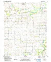 1991 Metz1991 Print · USGSThe rural landscape of Vernon County in the early 1990s is defined by the winding paths of the Little Osage and Marmaton Rivers. Genealogists and local historians can trace legacy sites like Rinehart Ch, the Old Railroad Grade, and several small country burial grounds including Rhea Cem.
 - 1991 Map of Garland
 1991 Garland1991 Print · USGSThe Kansas-Missouri border comes alive in the early nineties, showcasing the rural landscapes of Bourbon and Crawford Counties. Genealogists can locate several historic burial sites like Davis Cem and Shiloh Cem, or trace the path of Dry Wood Creek past the town of Arcadia.
 - 1991 Map of Rockville
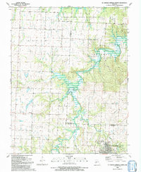
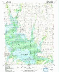 1991 Rockville1991 Print · USGSThe Osage River bottomlands near the Bates and Vernon county line define this late-century landscape. Genealogists and local historians can locate the Rockville Cem, explore the extensive Schell-Osage Wildlife Area, and trace the winding course of Panther Creek.
 - 1991 Map of Sprague
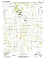 1991 Sprague1991 Print · USGSBates and Vernon counties in the early 1990s remained a landscape of quiet rural settlements and conservation lands. Genealogists and local historians can trace the positions of Greenlawn Cemetery, Bethel Ch, and the remnant Old RR Grade near Sprague.
 - 1991 Map of Nevada
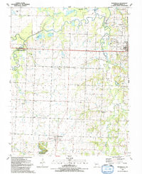
 1991 Nevada1991 Print · USGSThis borderland region in the early nineties captures the transition from Kansas plains to Missouri timber. Researchers can trace family history through Bunn Cemetery, locate the Camp Clark Military Reservation, and explore rail towns like Nevada and Fort Scott.
 - 1991 Map of Dederick, 1992 Print
 1991 Dederick1992 Print · USGSVernon County farmland and the prairie creeks of southwest Missouri are documented here in the late twentieth century. Family historians can locate several rural burial grounds including Stepp Cem and Butler Cem or trace the early foundations of Dederick and Sandstone.
End of results
Showing maps 1-17 of 17
Top cities of Vernon County
- Nevada historical maps
- Sheldon historical maps
- Schell City historical maps
- Walker historical maps
- Montevallo historical maps
- Bronaugh historical maps
See more
Frequently asked questions
- What are the different types of historical maps available for Vernon County?
- What is the oldest map of Vernon County?
- Where can I purchase historical maps of Vernon County for my home or office?
- Where can I download high-res historical maps of Vernon County?
- Are there historical topographic maps available for Vernon County?
- Is there historical aerial imagery available for Vernon County?
- Where are historical maps of Vernon County sourced from?