1990s Maps of Fair Haven, Missouri
Explore 2 historic maps of Fair Haven from the 1990s. These maps offer a rare glimpse into what life looked like during the 1990s — showing old roads, neighborhoods, homes, and landmarks that have changed or disappeared over time.
Whether you're researching your family's past, planning a metal detecting trip, or studying how Fair Haven's landscape evolved across the 1990s, these high-resolution maps are a powerful tool for exploring the history of this region.
- Focus on a specific era: All maps on this page are from the 1990s, giving you a focused view of this time period.
- See what’s changed: Compare century-old streets, trails, and buildings to today's modern landscape using overlays and satellite layers.
- Research with precision: Use these maps for genealogy, historical research, land use analysis, or educational projects.
- View, download, or print: Maps are fully viewable online in high resolution, and can be downloaded or printed for your own records.
Start exploring Fair Haven's history through authentic maps from the 1990s. This is your window into the past.
Fair Haven, MO maps
(2)- 1991 Map of Harwood
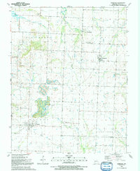 1991 Harwood1991 Print · USGSVernon County, Missouri, is captured here in the early nineties, showcasing the rural crossroads and drainage basins of the western plains. Genealogists and local historians can trace family sites near Fair Haven, Walker, and the Old Railroad Grade.
 - 1991 Map of Nevada
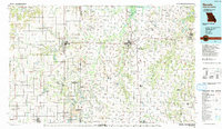 1991 Nevada1991 Print · USGSThis borderland region in the early nineties captures the transition from Kansas plains to Missouri timber. Researchers can trace family history through Bunn Cemetery, locate the Camp Clark Military Reservation, and explore rail towns like Nevada and Fort Scott.
End of results
Showing maps 1-2 of 2
Top cities near Fair Haven
- Nevada historical maps
- El Dorado Springs historical maps
- Rich Hill historical maps
- Appleton City historical maps
- Schell City historical maps
- Walker historical maps
See more
Frequently asked questions
- What are the different types of historical maps available for Fair Haven?
- What is the oldest map of Fair Haven?
- Where can I purchase historical maps of Fair Haven for my home or office?
- Where can I download high-res historical maps of Fair Haven?
- Are there historical topographic maps available for Fair Haven?
- Is there historical aerial imagery available for Fair Haven?
- Where are historical maps of Fair Haven sourced from?