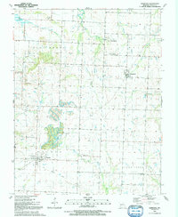
1991 Map of Harwood
USGS Topo · Published 1991About this map
The town of Walker and the small settlement of Harwood anchor this 1991 survey of Vernon County, Missouri. The landscape is defined by its subtle elevations and numerous watercourses, including the prominent Blue Mound, Green Mound, and Pepper Hill. Geographers and local historians can trace the legacy of early transit via the Old Railroad Grade that cuts through the southern portion of the quadrangle near Walker. Rural life is centered around community landmarks such as Living Faith Ch, Spring Park, and several burial grounds like Bethany Cem and Mt Vernon Ch Cem. The drainage patterns are intricate, with Coal Creek and the Ladies Branch feeding into the larger basin of Clear Creek, illustrating a classic prairie-creek topography before it meets the nearby reservoir systems.
Find a feature on this map
27 named features on this map. Tap any name to fly to it.
Don’t see what you’re looking for? This feature index may not catch every label — zoom into the map to look around manually.
Map Details
Editions of this 1991 Harwood Map
This is the sole edition of this map. No revisions or reprints were ever made.
Other maps of this area

1886 · Nevada
USGS Topo · 1:125,000

1887 · Butler
USGS Topo · 1:125,000

1894 · Butler
USGS Topo · 1:125,000

1894 · Nevada
USGS Topo · 1:125,000

1933 · Camp Clark
USGS Topo · 1:24,000

1934 · Papinsville
USGS Topo · 1:24,000

1934 · Rockville
USGS Topo · 1:24,000

1936 · Rich Hill
USGS Topo · 1:24,000

1938 · Horton
USGS Topo · 1:24,000

1939 · Horton
USGS Topo · 1:24,000