1900s (20th Century) Maps of Wright City, Missouri
Explore 14 historic maps of Wright City from the 1900s (20th Century). These maps offer a rare glimpse into what life looked like during the 1900s — showing old roads, neighborhoods, homes, and landmarks that have changed or disappeared over time.
Whether you're researching your family's past, planning a metal detecting trip, or studying how Wright City's landscape evolved across the 1900s, these high-resolution maps are a powerful tool for exploring the history of this region.
- Focus on a specific era: All maps on this page are from the 1900s, giving you a focused view of this time period.
- See what’s changed: Compare century-old streets, trails, and buildings to today's modern landscape using overlays and satellite layers.
- Research with precision: Use these maps for genealogy, historical research, land use analysis, or educational projects.
- View, download, or print: Maps are fully viewable online in high resolution, and can be downloaded or printed for your own records.
Start exploring Wright City's history through authentic maps from the 1900s. This is your window into the past.
Wright City, MO maps
(14)- 1903 Map of O'Fallon
 1903 O'Fallon1903 Print · USGSSt. Charles County at the turn of the century is a labyrinth of river islands and rail lines at the confluence of the Missouri and Mississippi. Researchers can trace old river landings like Cap Au Gris Landing and family-named settlements from Moscow Mills to New Melle.5 unique versions available
 - 1941 Map of Troy, 1964 Print
 1941 Troy1964 Print · USGSLincoln and St. Charles Counties are captured here in the early 1940s as the rail-and-river economy shaped local life. Researchers can trace dozens of rural schoolhouses and family landmarks like Pond Fort Sch, Shiloh Ch, and the Wabash RR junction at Wentzville.2 unique versions available
 - 1943 Map of Warrenton, 1962 Print
 1943 Warrenton1962 Print · USGSMissouri's rural heartland is meticulously detailed in the early 1940s, showing the vital rail corridors and crossroads communities of Warren and Lincoln counties. Genealogists and historians can locate dozens of small schoolhouses like Weeks Sch and Moore Sch alongside the tracks of the Wabash RR.2 unique versions available
 - 1945 Map of Troy
 1945 Troy1945 Print · USGSLincoln and St. Charles counties are shown in the 1940s, revealing a landscape of small farming hamlets and a high density of rural schoolhouses. Researchers can trace the paths of the Wabash RR and locate ancestral landmarks like Owen Station Sch or Oak Grove Cem.2 unique versions available
 - 1945 Map of Warrenton
 1945 Warrenton1945 Print · USGSWarrenton and Wright City thrive along the Wabash rail line in the mid-1940s, surrounded by a dense network of Missouri country schools and rural churches. Genealogists can trace family landmarks like Camp Branch Cem, Zion Ch, and the Goat Spring Sch.2 unique versions available
 - 1949 Map of Saint Louis
 1949 Saint Louis1949 Print · USGSGreater St. Louis and its surrounding river valleys are captured here just after the war, showing the metropolitan core and the rural Ozark fringe. Researchers can trace the sprawling rail network of the Wabash RR or locate landmarks like Meramec Caverns Airport and Scott Air Force Base.2 unique versions available
 - 1962 Map of St. Louis
 1962 St. Louis1962 Print · USGSThe mid-century gateway to the west shows the metropolitan expansion of St Louis alongside its critical river confluences. Genealogists and historians can trace the rail corridors of the Missouri Pacific RR and settlements from Fulton to De Soto.
 - 1963 Map of St. Louis, 1970 Print
 1963 St. Louis1970 Print · USGSSt. Louis and its surrounding river valleys are captured here during the peak of mid-century suburban expansion and industrial activity. Trace the historic rail routes of the Norfolk and Western Ry or locate the St Louis Ordnance Plant and early stretches of US Highway 66.4 unique versions available
 - 1966 Map of St. Louis
 1966 St. Louis1966 Print · USGSThe St. Louis metropolitan area and its surrounding river valleys are captured here during the mid-sixties era of suburban growth and industrial strength. Genealogists and historians can trace the foundations of local communities through sites like Old Pioneer Cem, Parks College, and the Jefferson Barracks Military Reservation.
 - 1972 Map of Foristell, 1973 Print
 1972 Foristell1973 Print · USGSForistell and the surrounding tri-county rural landscape appear here in the early seventies, caught between its rail-town roots and growing industrial utility. Researchers can locate family landmarks along Stringtown Road or trace sites like Smith Chapel and the Mid America Raceway.3 unique versions available
 - 1972 Map of Wright City, 1974 Print
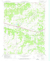
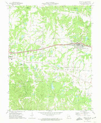 1972 Wright City1974 Print · USGSWright City and Truesdale are shown at a crossroads of rail and regional industry in the early seventies. Trace the Norfolk and Western line or locate local landmarks like Passionist Fathers Seminary and Harmonie Ch.2 unique versions available
 - 1979 Map of Foristell, 1980 Print
 1979 Foristell1980 Print · USGSThe Missouri countryside around Foristell is captured in late 1979 through high-resolution aerial imagery rather than traditional line drawing. Researchers can trace the exact 1970s land use patterns along Peruque Creek and the Fifth Principal Meridian.
 - 1985 Map of St Louis
 1985 St Louis1985 Print · USGSThe St. Louis metropolitan area and its river confluences are captured here during a period of significant suburban expansion in the 1980s. Genealogists and historians can trace the development of older neighborhoods and landmarks like Jefferson Barracks, Cahokia Mounds State Park, and Washington University.3 unique versions available
 - 1985 Map of Fulton
 1985 Fulton1985 Print · USGSMid-Missouri was a hub of river commerce and rail travel in the mid-1980s, where towns like Fulton and Hermann anchored the river valley. Researchers can trace historic river islands like Rush Island or follow the path of the Missouri - Kansas - Texas Railroad.2 unique versions available
End of results
Showing maps 1-14 of 14
Top cities near Wright City
- O'Fallon historical maps
- Wentzville historical maps
- Troy historical maps
- Warrenton historical maps
- Moscow Mills historical maps
- New Haven historical maps
See more
Frequently asked questions
- What are the different types of historical maps available for Wright City?
- What is the oldest map of Wright City?
- Where can I purchase historical maps of Wright City for my home or office?
- Where can I download high-res historical maps of Wright City?
- Are there historical topographic maps available for Wright City?
- Is there historical aerial imagery available for Wright City?
- Where are historical maps of Wright City sourced from?