1990s Maps of Horton Town, Missouri
Explore 1 historic maps of Horton Town from the 1990s. These maps offer a rare glimpse into what life looked like during the 1990s — showing old roads, neighborhoods, homes, and landmarks that have changed or disappeared over time.
Whether you're researching your family's past, planning a metal detecting trip, or studying how Horton Town's landscape evolved across the 1990s, these high-resolution maps are a powerful tool for exploring the history of this region.
- Focus on a specific era: All maps on this page are from the 1990s, giving you a focused view of this time period.
- See what’s changed: Compare century-old streets, trails, and buildings to today's modern landscape using overlays and satellite layers.
- Research with precision: Use these maps for genealogy, historical research, land use analysis, or educational projects.
- View, download, or print: Maps are fully viewable online in high resolution, and can be downloaded or printed for your own records.
Start exploring Horton Town's history through authentic maps from the 1990s. This is your window into the past.
Horton Town, MO maps
(1)- 1999 Map of Palmer, 2002 Print
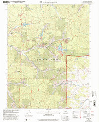 1999 Palmer2002 Print · USGSThe Missouri mining country around Palmer and the Big River is shown here just before the turn of the millennium. Genealogists can trace family names at Sitton Cem, Marler Chapel, and McClain Cem or locate forgotten sites like Delbridge and Sunlight.
End of results
Showing maps 1-1 of 1
Top cities near Horton Town
- Potosi historical maps
- Viburnum historical maps
- Mineral Point historical maps
- Caledonia historical maps
Frequently asked questions
- What are the different types of historical maps available for Horton Town?
- What is the oldest map of Horton Town?
- Where can I purchase historical maps of Horton Town for my home or office?
- Where can I download high-res historical maps of Horton Town?
- Are there historical topographic maps available for Horton Town?
- Is there historical aerial imagery available for Horton Town?
- Where are historical maps of Horton Town sourced from?