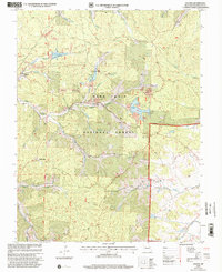
1999 Map of Palmer
USGS Topo · Published 2002About this map
Palmer sits at the heart of this landscape, once a focal point for lead mining operations within what is now the Mark Twain National Forest. The map documents a territory defined by deep extraction, where numerous mines and areas of tailings are clustered around Parole Lake, Howell Lake, and Palmer Lake. This industrial legacy is contrasted by a significant concentration of small family and church burial grounds, including Sitton Cem, Scott Cem, and the Lizzie Ch Jenkins Cem near Lizzie Ch.
Find a feature on this map
43 named features on this map. Tap any name to fly to it.
Don’t see what you’re looking for? This feature index may not catch every label — zoom into the map to look around manually.
Map Details
Editions of this 1999 Palmer Map
This is the sole edition of this map. No revisions or reprints were ever made.
Other maps of this area

1906 · Potosi
USGS Topo · 1:62,500

1924 · Edgehill
USGS Topo · 1:62,500

1926 · Edgehill
USGS Topo · 1:62,500

1943 · Berryman
USGS Topo · 1:62,500

1943 · Boss
USGS Topo · 1:62,500

1945 · Berryman
USGS Topo · 1:62,500

1946 · Boss
USGS Topo · 1:62,500

1949 · Rolla
USGS Topo · 1:250,000

1953 · Rolla
USGS Topo · 1:250,000

1954 · Rolla
USGS Topo · 1:250,000