
1953 Map of Rolla
USGS Topo · Published 1953About this map
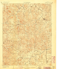
The St. Francois Mountains and the surrounding Ozark Plateau anchor this mid-century portrait of southeast Missouri. Deeply dissected terrain is punctuated by significant heights like Taum Sauk Mt and Pilot Knob, which overlook a network of mining and industrial towns. The map reveals the early post-war development of regional infrastructure, including the newly formed Clearwater Reservoir and Wappapello Reservoir. Transport is dominated by the St. Louis-San Francisco Ry and the Missouri Pacific RR, alongside the legendary U.S. 66 corridor cutting through Rolla, St. James, and Cuba. The distribution of timber within the Mark Twain National Forest and various divisions of the Clark National Forest illustrates the balance between natural resource conservation and the established lead-belt communities like Bonne Terre and Flat River.
Find a feature on this map
75 named features on this map. Tap any name to fly to it.
Don’t see what you’re looking for? This feature index may not catch every label — zoom into the map to look around manually.
Map Details
Editions of this 1953 Rolla Map
This is the sole edition of this map. No revisions or reprints were ever made.
Other maps of this area

1888 · Tuscumbia
USGS Topo · 1:125,000

1894 · Tuscumbia
USGS Topo · 1:125,000

1901 · De Soto
USGS Topo · 1:125,000

1903 · Sullivan
USGS Topo · 1:125,000

1904 · Farmington
USGS Topo · 1:62,500

1905 · Bonneterre
USGS Topo · 1:62,500
1906 · Potosi
USGS Topo · 1:62,500

1906 · Farmington
USGS Topo · 1:62,500

1907 · Weingarten
USGS Topo · 1:62,500

1909 · Weingarten
USGS Topo · 1:62,500