1930s Maps of Kime, Missouri
Explore 2 historic maps of Kime from the 1930s. These maps offer a rare glimpse into what life looked like during the 1930s — showing old roads, neighborhoods, homes, and landmarks that have changed or disappeared over time.
Whether you're researching your family's past, planning a metal detecting trip, or studying how Kime's landscape evolved across the 1930s, these high-resolution maps are a powerful tool for exploring the history of this region.
- Focus on a specific era: All maps on this page are from the 1930s, giving you a focused view of this time period.
- See what’s changed: Compare century-old streets, trails, and buildings to today's modern landscape using overlays and satellite layers.
- Research with precision: Use these maps for genealogy, historical research, land use analysis, or educational projects.
- View, download, or print: Maps are fully viewable online in high resolution, and can be downloaded or printed for your own records.
Start exploring Kime's history through authentic maps from the 1930s. This is your window into the past.
Kime, MO maps
(2)- 1934 Map of Greenville
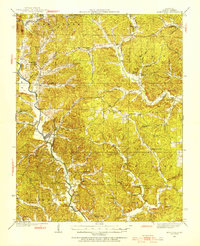 1934 Greenville1934 Print · USGSWayne County, Missouri, is shown here in the mid-1930s, documenting a landscape of tight-knit river communities and rural hill schools. Genealogists can trace family landmarks like Smoot Cem, locate the CCC Camp, or find local centers like Silva PO and Holmes Chapel Sch & Ch.2 unique versions available
 - 1939 Map of Greenville
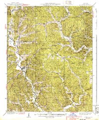 1939 Greenville1939 Print · USGSWayne County during the late thirties reveals a landscape of tight-knit river communities and rural schools along the St Francis River. Genealogists and historians can trace local family roots through sites like Montgomery Ch, Bounds Cem, and the CCC Camp.2 unique versions available
End of results
Showing maps 1-2 of 2
Top cities near Kime
Frequently asked questions
- What are the different types of historical maps available for Kime?
- What is the oldest map of Kime?
- Where can I purchase historical maps of Kime for my home or office?
- Where can I download high-res historical maps of Kime?
- Are there historical topographic maps available for Kime?
- Is there historical aerial imagery available for Kime?
- Where are historical maps of Kime sourced from?