1970s Maps of Silva, Missouri
Explore 2 historic maps of Silva from the 1970s. These maps offer a rare glimpse into what life looked like during the 1970s — showing old roads, neighborhoods, homes, and landmarks that have changed or disappeared over time.
Whether you're researching your family's past, planning a metal detecting trip, or studying how Silva's landscape evolved across the 1970s, these high-resolution maps are a powerful tool for exploring the history of this region.
- Focus on a specific era: All maps on this page are from the 1970s, giving you a focused view of this time period.
- See what’s changed: Compare century-old streets, trails, and buildings to today's modern landscape using overlays and satellite layers.
- Research with precision: Use these maps for genealogy, historical research, land use analysis, or educational projects.
- View, download, or print: Maps are fully viewable online in high resolution, and can be downloaded or printed for your own records.
Start exploring Silva's history through authentic maps from the 1970s. This is your window into the past.
Silva, MO maps
(2)- 1970 Map of Greenville
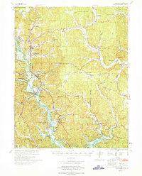 1970 Greenville1970 Print · USGSThe St Francis River valley and Wappapello Lake shoreline are captured in the late sixties, showing the rural communities of Wayne County. Trace family roots at Old Greenville Cem and explore landmarks like White Hollow Sch and Logan Mountain.
 - 1971 Map of Rolla
 1971 Rolla1971 Print · USGSThe Missouri Ozarks are captured here during the early seventies, showing a landscape of deep river valleys and industrial mining towns. Researchers can trace historic lead mining operations at St Joseph Mines and locate rural landmarks like Viburnum and the Galveston Trail.
End of results
Showing maps 1-2 of 2
Top cities near Silva
- Piedmont historical maps
- Greenville historical maps
- Williamsville historical maps
- Annapolis historical maps
- Mill Spring historical maps
- Des Arc historical maps
Frequently asked questions
- What are the different types of historical maps available for Silva?
- What is the oldest map of Silva?
- Where can I purchase historical maps of Silva for my home or office?
- Where can I download high-res historical maps of Silva?
- Are there historical topographic maps available for Silva?
- Is there historical aerial imagery available for Silva?
- Where are historical maps of Silva sourced from?