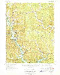
1970 Map of Greenville
USGS Topo · Published 1970About this map
St Francis River flows through the heart of Wayne County, its course heavily influenced by the presence of Wappapello Lake to the south. This area is characterized by the expansive Clark National Forest and the northern reach of Sam A Baker State Park, where Logan Mountain rises above Camp Lewallen. The map captures a moment of transition for the town of Greenville, showing the Old Greenville Cem near the riverbanks while newer developments like Missionary Acres sit on higher ground. Local life is centered around rural landmarks such as White Hollow Sch, Wesley Chapel, and Hiram Sch. Genealogists will find a wealth of family history in the numerous burial grounds scattered across the terrain, including Kirk Cem, Helm Cem, and the Ward Cem in the northeast corner.
Find a feature on this map
101 named features on this map. Tap any name to fly to it.
Don’t see what you’re looking for? This feature index may not catch every label — zoom into the map to look around manually.
Map Details
Editions of this 1970 Greenville Map
This is the sole edition of this map. No revisions or reprints were ever made.
Other maps of this area

1926 · Des Arc
USGS Topo · 1:62,500

1929 · Des Arc
USGS Topo · 1:62,500

1930 · Coldwater
USGS Topo · 1:62,500

1932 · Piedmont
USGS Topo · 1:62,500

1933 · Marquand
USGS Topo · 1:62,500

1934 · Greenville
USGS Topo · 1:62,500

1934 · Williamsville
USGS Topo · 1:48,000

1934 · Puxico
USGS Topo · 1:62,500

1935 · Poplar Bluff
USGS Topo · 1:62,500

1935 · Zalma
USGS Topo · 1:62,500