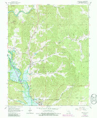
1966 Map of Greenville
USGS Topo · Published 1985About this map
Greenville and the winding St Francis River valley define this portion of Wayne County, captured here as the landscape shifted through the mid-1960s and 1980s. The area is heavily managed for conservation and recreation, dominated by the Mark Twain National Forest and the Lake Wappapello State Wildlife Management Area. Cultural landmarks are scattered along the river's tributaries, including the White Hollow Sch and several country churches such as New Liberty Ch and Mt Pisgah Ch. Smaller settlements like Silva and Bounds are situated along the primary north-south corridor, while the Fish Hatchery near Silva points to the region's focus on water resources. From the heights of Logan Mountain to the depths of Rebel Cave, the map provides a clear record of the rural communities and public lands surrounding the upper reaches of Lake Wappapello.
Find a feature on this map
42 named features on this map. Tap any name to fly to it.
Don’t see what you’re looking for? This feature index may not catch every label — zoom into the map to look around manually.
Map Details
Editions of this 1966 Greenville Map
3 editions found
Other maps of this area

1926 · Des Arc
USGS Topo · 1:62,500

1929 · Des Arc
USGS Topo · 1:62,500

1930 · Coldwater
USGS Topo · 1:62,500

1932 · Piedmont
USGS Topo · 1:62,500

1934 · Greenville
USGS Topo · 1:62,500

1935 · Piedmont
USGS Topo · 1:62,500

1939 · Greenville
USGS Topo · 1:62,500

1949 · Rolla
USGS Topo · 1:250,000

1949 · Coldwater
USGS Topo · 1:62,500

1953 · Rolla
USGS Topo · 1:250,000