
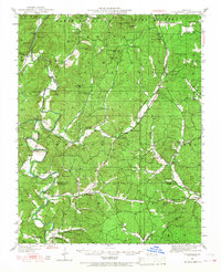
1949 Map of Coldwater
USGS Topo · Published 1955About this map
The St Francis River dictates the landscape of this southern Missouri region, winding through the borderlands of Saint Francois, Madison, and Wayne counties. In the late 1940s, this area remained defined by small-scale rural infrastructure, evidenced by numerous river crossings like Marsh Ford, Shelton Ford, and Reed Bend Ford. Settlements such as French Mills and Coldwater serve as focal points for a community connected by a network of one-room schools, including Mt Pisgah Sch and Reed Bend Sch, and country churches like Tantrough Ch and Miller Chapel.
Find a feature on this map
73 named features on this map. Tap any name to fly to it.
Don’t see what you’re looking for? This feature index may not catch every label — zoom into the map to look around manually.
Map Details
Editions of this 1949 Coldwater Map
2 editions found
Other maps of this area

1910 · Higdon
USGS Topo · 1:62,500

1926 · Des Arc
USGS Topo · 1:62,500

1929 · Des Arc
USGS Topo · 1:62,500

1930 · Coldwater
USGS Topo · 1:62,500

1932 · Piedmont
USGS Topo · 1:62,500

1933 · Marquand
USGS Topo · 1:62,500

1934 · Greenville
USGS Topo · 1:62,500

1935 · Zalma
USGS Topo · 1:62,500

1935 · Piedmont
USGS Topo · 1:62,500

1937 · Ironton
USGS Topo · 1:48,000