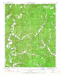
1949 Map of Coldwater
USGS Topo · Published 1968About this map
Saint Francois National Forest anchors this mid-century portrait of southeastern Missouri, where the rugged terrain of the St. Francois Mountains meets a network of river-bottom settlements. The St Francis River winds through the western half of the sheet, connected by essential river crossings like Wide Ford and Reed Bend Ford. In an era before modern highway expansion, local life centered on community anchors such as French Mills and rural commerce hubs like Twelvemile Store and Chubb Store. These small outposts, alongside Gravelton and Coldwater, were supported by a dense distribution of country schools, including King Sch and Mt Pisgah Sch. The map reveals a landscape defined by family-named peaks like Marlow Mtn and Matthews Mtn, illustrating the historical geography of Madison and Wayne counties during a period of established rural tradition.
Find a feature on this map
69 named features on this map. Tap any name to fly to it.
Don’t see what you’re looking for? This feature index may not catch every label — zoom into the map to look around manually.
Map Details
Editions of this 1949 Coldwater Map
2 editions found

Other maps of this area

1910 · Higdon
USGS Topo · 1:62,500

1926 · Des Arc
USGS Topo · 1:62,500

1929 · Des Arc
USGS Topo · 1:62,500

1930 · Coldwater
USGS Topo · 1:62,500

1932 · Piedmont
USGS Topo · 1:62,500

1933 · Marquand
USGS Topo · 1:62,500

1934 · Greenville
USGS Topo · 1:62,500

1935 · Zalma
USGS Topo · 1:62,500

1935 · Piedmont
USGS Topo · 1:62,500

1937 · Ironton
USGS Topo · 1:48,000