
1939 Map of Greenville
USGS Topo · Published 1939About this map
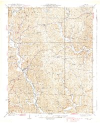
Greenville sits at a strategic bend where the St Francis River flows south, serving as a hub for Wayne County during the 1930s. The landscape is defined by the winding paths of Lost Creek and Cedar Creek, with rural life organized around dozens of small community anchors like Holmes Chapel Sch and Wesley Chapel. The presence of a CCC Camp in the western hills reflects the era's federal investment in conservation and labor. Further east, the terrain around Lowndes and Burbank is marked by intricate drainage systems such as Roach Branch and Goose Creek. Significant local history is preserved in the naming of family-related landmarks, including Bounds Cem and Childers Hill, which provide a detailed account of the settlement patterns and local lineage before the mid-century evolution of the river basin.
Find a feature on this map
78 named features on this map. Tap any name to fly to it.
Don’t see what you’re looking for? This feature index may not catch every label — zoom into the map to look around manually.
Map Details
Editions of this 1939 Greenville Map
2 editions found
Other maps of this area

1926 · Des Arc
USGS Topo · 1:62,500

1929 · Des Arc
USGS Topo · 1:62,500

1930 · Coldwater
USGS Topo · 1:62,500

1932 · Piedmont
USGS Topo · 1:62,500

1933 · Marquand
USGS Topo · 1:62,500

1934 · Greenville
USGS Topo · 1:62,500

1934 · Williamsville
USGS Topo · 1:48,000

1934 · Puxico
USGS Topo · 1:62,500

1935 · Poplar Bluff
USGS Topo · 1:62,500

1935 · Zalma
USGS Topo · 1:62,500