Old Maps of Alpine, Montana for Metal Detecting
Plan your next treasure hunt with 13 historic maps of Alpine. Find old homesites, ghost towns, trails, and gathering spots that may be lost to time — perfect for identifying promising metal detecting locations.
- Locate forgotten sites: Uncover places like long-lost settlements, abandoned rail lines, or gathering spots.
- Plan better hunts: Use map overlays combined with LiDAR or satellite views to narrow in on historically rich areas.
- Made for detectorists: Thousands of hobbyists use these maps to discover relics, coins, and hidden history.
Use these historic maps to boost your research and find new opportunities beneath the surface of Alpine.
Alpine, MT maps
(13)- 1898 Map of Granite Mountain District
 1898 Granite Mountain District1898 Print · USGSThe Beartooth Range appears here in the late nineteenth century during a specialized survey for regional coal and electric companies. Researchers can trace early mountain pathways through Goose Lake Pass and locate major summits like Granite Peak and Mt Dewey.
 - 1954 Map of Billings, 1963 Print
 1954 Billings1963 Print · USGSThe Yellowstone valley during the mid-fifties shows a landscape of thriving rail towns and high-mountain outposts. Genealogists and historians can trace old homesteads and mining routes near Red Lodge, Bearcreek, and along the Bighorn River.4 unique versions available
 - 1956 Map of Alpine, 1957 Print
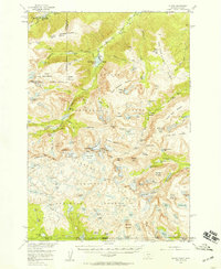 1956 Alpine1957 Print · USGSThe Beartooth Range at the mid-century is captured here in immense detail, showing the glacial peaks and alpine lakes of the Montana-Wyoming border. Trace high-altitude landmarks like the Mystic Lake Hydroelectric Plant, the settlement at Alpine, and the rugged paths of the Arch Creek Trail.3 unique versions available
 - 1957 Map of Billings
 1957 Billings1957 Print · USGSThe Yellowstone River valley and the rugged Beartooth Mountains meet in the mid-1950s near the growing hub of Billings. Genealogists and researchers can trace rail and ranching history through river towns like Columbus, the mining heritage of Red Lodge, and the vast Crow Indian Reservation.
 - 1958 Map of Billings
 1958 Billings1958 Print · USGSMid-century Montana comes alive in this survey of the Yellowstone Valley as the regional rail and road networks reached their peak. Trace family roots and old routes near Billings, the Crow Indian Reservation, and the heights of the Beartooth Mountains.2 unique versions available
 - 1986 Map of Alpine
 1986 Alpine1986 Print · USGSThe Beartooth Mountains are captured here in the mid-1980s, revealing a landscape of high-altitude lakes and pack trails. Study the trail access to Alpine or trace the drainage from Phantom Glacier past Froze-to-Death Lake and Rainbow Lake.
 - 1989 Map of Red Lodge
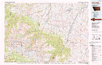 1989 Red Lodge1989 Print · USGSThe Beartooth Mountains and the Montana-Wyoming border come alive in this late 1980s map of the high plateau country. Genealogists and historians can trace the mining history of Bearcreek through the Brophy Mine and Foster Mine or locate the rural Church Hill.
 - 1996 Map of Alpine, 1999 Print
 1996 Alpine1999 Print · USGSThe Beartooth Wilderness in the mid-1990s was a landscape of high-altitude glacial lakes and isolated settlements. Researchers can trace the drainages of West Rosebud Lake and East Rosebud Lake while locating the remote Phantom Glacier and Alpine trailhead.
 - 2011 Map of Alpine, 2011 Print
 2011 Alpine2011 Print · USGSCovers Alpine, including Carbon County, Stillwater County, and other nearby areas
 - 2014 Map of Alpine, 2014 Print
 2014 Alpine2014 Print · USGSCovers Alpine, including Carbon County, Stillwater County, and other nearby areas
 - 2017 Map of Alpine, 2017 Print
 2017 Alpine2017 Print · USGSCovers Alpine, including Carbon County, Stillwater County, and other nearby areas
 - 2020 Map of Alpine, 2020 Print
 2020 Alpine2020 Print · USGSCovers Alpine, including Carbon County, Stillwater County, and other nearby areas
 - 2024 Map of Alpine, 2024 Print
 2024 Alpine2024 Print · USGSThe settlement of Alpine serves as the threshold for the high Beartooth range in the twenty-first century. Researchers can trace the drainage of the East Rosebud Creek Wild and Scenic River and locate remote landmarks like Phantom Glacier and Rainbow Lake.
End of results
Showing maps 1-13 of 13
Frequently asked questions
- What are the different types of historical maps available for Alpine?
- What is the oldest map of Alpine?
- Where can I purchase historical maps of Alpine for my home or office?
- Where can I download high-res historical maps of Alpine?
- Are there historical topographic maps available for Alpine?
- Is there historical aerial imagery available for Alpine?
- Where are historical maps of Alpine sourced from?