
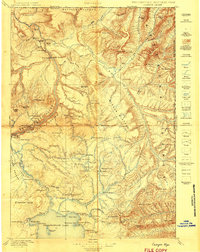
1898 Map of Granite Mountain District
USGS Topo · Published 1898About this map
James P. Kimball led this reconnaissance survey of the high-elevation terrain in the Beartooth Range, commissioned specifically for industrial interests including the Rocky Fork Coal Co. and the Rocky Fork Town and Electric Co. The map provides an early look at the extreme topography of the Beartooth Plateau, where massive summits like Granite Peak and Mt Weed dominate the landscape. The drainage patterns are meticulously traced along the Stillwater River and the bifurcated branches of West Rosebud Creek and East Rosebud Creek. Distinctive landmarks such as Mystic Lake and Goose Lake Pass suggest the routes and water sources prioritized during this late nineteenth-century geological study. The inclusion of industrial sponsors in the margin highlights the era's drive to identify mineral and energy resources within the high mountain districts.
Find a feature on this map
16 named features on this map. Tap any name to fly to it.
Don’t see what you’re looking for? This feature index may not catch every label — zoom into the map to look around manually.
Map Details
Editions of this 1898 Granite Mountain District Map
This is the sole edition of this map. No revisions or reprints were ever made.
Other maps of this area

1886 · Canyon
USGS Topo · 1:125,000

1891 · Livingston
USGS Topo · 1:250,000

1891 · Big Timber
USGS Topo · 1:125,000

1892 · Stillwater
USGS Topo · 1:125,000

1893 · Livingston
USGS Topo · 1:250,000

1893 · Big Timber
USGS Topo · 1:125,000

1895 · Canyon
USGS Topo · 1:125,000
1896 · Canyon
USGS Topo · 1:125,000
1896 · Crandall Creek
USGS Topo · 1:125,000
1899 · Crandall
USGS Topo · 1:125,000