1900s (20th Century) Maps of Warrick, Montana
Explore 6 historic maps of Warrick from the 1900s (20th Century). These maps offer a rare glimpse into what life looked like during the 1900s — showing old roads, neighborhoods, homes, and landmarks that have changed or disappeared over time.
Whether you're researching your family's past, planning a metal detecting trip, or studying how Warrick's landscape evolved across the 1900s, these high-resolution maps are a powerful tool for exploring the history of this region.
- Focus on a specific era: All maps on this page are from the 1900s, giving you a focused view of this time period.
- See what’s changed: Compare century-old streets, trails, and buildings to today's modern landscape using overlays and satellite layers.
- Research with precision: Use these maps for genealogy, historical research, land use analysis, or educational projects.
- View, download, or print: Maps are fully viewable online in high resolution, and can be downloaded or printed for your own records.
Start exploring Warrick's history through authentic maps from the 1900s. This is your window into the past.
Warrick, MT maps
(6)- 1953 Map of Havre, 1967 Print
 1953 Havre1967 Print · USGSNorthern Montana’s Hi-Line comes into focus in the mid-fifties, centered on the Milk River and the critical Great Northern rail link. Genealogists can trace small sidings and settlements like Assinniboine, Laredo, and Box Elder alongside the Fort Belknap Agency.3 unique versions available
 - 1957 Map of Havre
 1957 Havre1957 Print · USGSNorth-central Montana at the mid-century is defined by the vital Great Northern rail corridor and the winding Milk River. Researchers can trace old settlements like Laredo and Savoy, or locate historic sites such as the Hays (old) Sub Agency and the Chinook No 1 mine.
 - 1958 Map of Havre
 1958 Havre1958 Print · USGSUpper Montana in the late fifties was a landscape of remote rail towns and vast high-plain ranges. Genealogists and historians can trace the Great Northern railroad through Havre, Chinook, and the Fort Belknap Indian Reservation.
 - 1959 Map of Warrick, 1961 Print
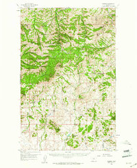 1959 Warrick1961 Print · USGSThe Bearpaw Mountains of North Central Montana were still a landscape of remote ranching and reservation life in the late fifties. Researchers can trace the grounds of the Upper Dog Creek Sch, the Silver King Mine, and the isolated community of Warrick.3 unique versions available
 - 1984 Map of Warrick
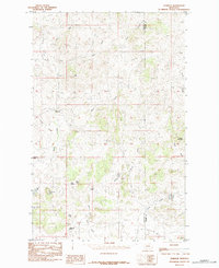 1984 Warrick1984 Print · USGSNorth-Central Montana in the mid-1980s was defined by its cattle-country topography and vital water sources. Researchers can trace land use through named landmarks like Rattlesnake Butte and reliable water points such as Polish Spring and Gasparage Spring.
 - 1993 Map of Rocky Boy, 1994 Print
 1993 Rocky Boy1994 Print · USGSThe Bears Paw Mountains and the high plains of north-central Montana appear here in the early nineties, centered on the Rocky Boys Indian Reservation. You can trace the historic Bears Paw Battlefield and find isolated sites like Cleveland and the Blackjack Mine.
End of results
Showing maps 1-6 of 6
Frequently asked questions
- What are the different types of historical maps available for Warrick?
- What is the oldest map of Warrick?
- Where can I purchase historical maps of Warrick for my home or office?
- Where can I download high-res historical maps of Warrick?
- Are there historical topographic maps available for Warrick?
- Is there historical aerial imagery available for Warrick?
- Where are historical maps of Warrick sourced from?