1980s Maps of Ollie, Montana
Explore 2 historic maps of Ollie from the 1980s. These maps offer a rare glimpse into what life looked like during the 1980s — showing old roads, neighborhoods, homes, and landmarks that have changed or disappeared over time.
Whether you're researching your family's past, planning a metal detecting trip, or studying how Ollie's landscape evolved across the 1980s, these high-resolution maps are a powerful tool for exploring the history of this region.
- Focus on a specific era: All maps on this page are from the 1980s, giving you a focused view of this time period.
- See what’s changed: Compare century-old streets, trails, and buildings to today's modern landscape using overlays and satellite layers.
- Research with precision: Use these maps for genealogy, historical research, land use analysis, or educational projects.
- View, download, or print: Maps are fully viewable online in high resolution, and can be downloaded or printed for your own records.
Start exploring Ollie's history through authentic maps from the 1980s. This is your window into the past.
Ollie, MT maps
(2)- 1981 Map of Ollie
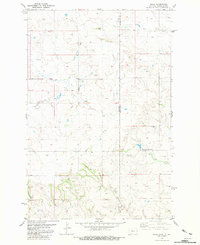 1981 Ollie1981 Print · USGSThe Montana and North Dakota borderlands come alive in this early eighties survey of the Fallon County region. Genealogists and historians can trace the Old Railroad Grade past the settlement of Ollie and follow the paths of Beaver Creek and Horse Creek.
 - 1981 Map of Wibaux, 1982 Print
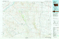 1981 Wibaux1982 Print · USGSThe Montana and North Dakota borderlands come into focus in the early 1980s, showcasing a landscape shaped by the BURLINGTON NORTHERN railroad and the Yellowstone River. Researchers can trace the rail corridor through Wibaux and Yates or locate isolated landmarks like Graveyard Hill and Johnstone Dam.
End of results
Showing maps 1-2 of 2
Top cities near Ollie
Frequently asked questions
- What are the different types of historical maps available for Ollie?
- What is the oldest map of Ollie?
- Where can I purchase historical maps of Ollie for my home or office?
- Where can I download high-res historical maps of Ollie?
- Are there historical topographic maps available for Ollie?
- Is there historical aerial imagery available for Ollie?
- Where are historical maps of Ollie sourced from?