1980s Maps of Fords Creek Hutterite Colony, Montana
Explore 2 historic maps of Fords Creek Hutterite Colony from the 1980s. These maps offer a rare glimpse into what life looked like during the 1980s — showing old roads, neighborhoods, homes, and landmarks that have changed or disappeared over time.
Whether you're researching your family's past, planning a metal detecting trip, or studying how Fords Creek Hutterite Colony's landscape evolved across the 1980s, these high-resolution maps are a powerful tool for exploring the history of this region.
- Focus on a specific era: All maps on this page are from the 1980s, giving you a focused view of this time period.
- See what’s changed: Compare century-old streets, trails, and buildings to today's modern landscape using overlays and satellite layers.
- Research with precision: Use these maps for genealogy, historical research, land use analysis, or educational projects.
- View, download, or print: Maps are fully viewable online in high resolution, and can be downloaded or printed for your own records.
Start exploring Fords Creek Hutterite Colony's history through authentic maps from the 1980s. This is your window into the past.
Fords Creek Hutterite Colony, MT maps
(2)- 1986 Map of Grass Range NW
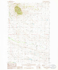 1986 Grass Range NW1986 Print · USGSCentral Montana ranching lands are captured in the mid-eighties just as the landscape was being documented through provisional surveying. Genealogists and historians can trace the Bell Ranch Colony and local landmarks like Black Butte and Brickyard Creek.
 - 1986 Map of Winnett, 1994 Print
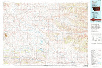 1986 Winnett1994 Print · USGSCentral Montana ranching country is shown here in the mid-1980s as the rail era had given way to modern highways. Researchers can trace the Old Railroad Grade past Teigen or locate family sites near Wild Horse Lake and the War Horse National Wildlife Refuge.
End of results
Showing maps 1-2 of 2
Top cities near Fords Creek Hutterite Colony
Frequently asked questions
- What are the different types of historical maps available for Fords Creek Hutterite Colony?
- What is the oldest map of Fords Creek Hutterite Colony?
- Where can I purchase historical maps of Fords Creek Hutterite Colony for my home or office?
- Where can I download high-res historical maps of Fords Creek Hutterite Colony?
- Are there historical topographic maps available for Fords Creek Hutterite Colony?
- Is there historical aerial imagery available for Fords Creek Hutterite Colony?
- Where are historical maps of Fords Creek Hutterite Colony sourced from?