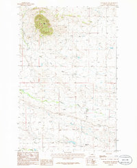
1986 Map of Grass Range NW
USGS Topo · Published 1986About this map
Black Butte rises prominently above the rolling landscape of central Fergus County in this mid-1980s provisional survey. The map details a transition from the elevated terrain in the northwest down toward the drainages of South Fork Bear Creek and Brickyard Creek. This area of Montana reflects a primarily agricultural and ranching character, anchored by the presence of the Bell Ranch Colony in the southern portion of the quadrangle. Local industry and infrastructure are represented by a Gravel Pit near the base of the hills, while the southern boundary follows the path of Fords Creek. The intricate contour lines illustrate a landscape carved by seasonal waterways and intermittent springs, typical of the high plains of the American West before modern intensive development.
Find a feature on this map
8 named features on this map. Tap any name to fly to it.
Don’t see what you’re looking for? This feature index may not catch every label — zoom into the map to look around manually.
Map Details
Editions of this 1986 Grass Range NW Map
This is the sole edition of this map. No revisions or reprints were ever made.
Other maps of this area

1941 · Judith Peak
USGS Topo · 1:62,500

1944 · Judith Peak
USGS Topo · 1:62,500

1954 · Lewistown
USGS Topo · 1:250,000

1959 · Lewistown
USGS Topo · 1:250,000

1978 · Lewistown
USGS Topo · 1:100,000

1985 · Fergus
USGS Topo · 1:24,000

1985 · Roy
USGS Topo · 1:24,000
1985 · Bohemian Corners
USGS Topo · 1:24,000
1985 · Lewis Peak
USGS Topo · 1:24,000
1985 · Horsethief Coulee East
USGS Topo · 1:24,000