1978 Map of Lewistown
USGS Topo · Published 1994About this map
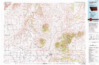
The Judith Mountains dominate the central landscape of this 1978 survey, with summits like New Year Peak and Maiden Peak rising above the surrounding central Montana plains. The regional hub of Lewistown serves as a junction for the Burlington Northern railroad and major roadways like U.S. 191. The map reveals a distinct pattern of agricultural and communal settlement, highlighting the Spring Creek Colony and Deerfield Colony alongside numerous named benches and flats such as Pacer Bench and Marshall Flat. Along the western edge, the Judith River and its tributary Ross Fork carve through the terrain, supporting a network of small rail towns including Moccasin, Hobson, and Denton. The presence of Giltedge in the eastern mountains and the various ranch airports across the county suggest the area's multifaceted reliance on mining, ranching, and localized aviation during the late 20th century.
Find a feature on this map
123 named features on this map. Tap any name to fly to it.
Don’t see what you’re looking for? This feature index may not catch every label — zoom into the map to look around manually.
Map Details
Editions of this 1978 Lewistown Map
This is the sole edition of this map. No revisions or reprints were ever made.
Other maps of this area

1886 · Little Belt Mts.
USGS Topo · 1:250,000

1889 · Big Snowy Mountain
USGS Topo · 1:250,000

1890 · Fort Benton
USGS Topo · 1:250,000

1892 · Fort Benton
USGS Topo · 1:250,000

1893 · Big Snowy Mountain
USGS Topo · 1:250,000

1894 · Little Belt Mts.
USGS Topo · 1:250,000

1897 · Fort Benton
USGS Topo · 1:250,000

1897 · Little Belt Mts.
USGS Topo · 1:250,000

1898 · Little Belt Mts.
USGS Topo · 1:250,000

1902 · Little Belt Mts.
USGS Topo · 1:250,000