
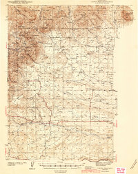
1944 Map of Judith Peak
USGS Topo · Published 1944About this map
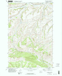
The gold and silver mining districts of the Judith Mountains are documented here during the early 1940s, centered on high summits like Judith Peak and Red Mtn. The landscape is a study in Montana's mineral rush history, featuring the Ruins of Fort Maginnis and its associated Fort Maginnis Cem alongside active and former mining camps. Significant workings such as the Spotted Horse Mine and Gilt Edge Mine are interspersed with several rural schools, including Pleasant Plains Sch and Cheadle Sch. To the south, the Great Northern Railroad Grade cuts a horizontal path across the plains near Alkali Creek, providing a stark contrast between the industrial mountain operations and the wide-open prairie. The map details a complex network of gulches and peaks, capturing the era when places like Maiden and Giltedge served as essential hubs for the region's extraction economy.
Find a feature on this map
54 named features on this map. Tap any name to fly to it.
Don’t see what you’re looking for? This feature index may not catch every label — zoom into the map to look around manually.
Map Details
Editions of this 1944 Judith Peak Map
2 editions found
Other maps of this area

1889 · Big Snowy Mountain
USGS Topo · 1:250,000

1893 · Big Snowy Mountain
USGS Topo · 1:250,000
1941 · Lewistown
USGS Topo · 1:62,500
1941 · Judith Peak
USGS Topo · 1:62,500
1944 · Lewistown
USGS Topo · 1:62,500

1954 · Roundup
USGS Topo · 1:250,000

1954 · Lewistown
USGS Topo · 1:250,000

1958 · Roundup
USGS Topo · 1:250,000

1959 · Lewistown
USGS Topo · 1:250,000
1970 · Forestgrove
USGS Topo · 1:24,000