1940s Maps of Maiden, Montana
Explore 2 historic maps of Maiden from the 1940s. These maps offer a rare glimpse into what life looked like during the 1940s — showing old roads, neighborhoods, homes, and landmarks that have changed or disappeared over time.
Whether you're researching your family's past, planning a metal detecting trip, or studying how Maiden's landscape evolved across the 1940s, these high-resolution maps are a powerful tool for exploring the history of this region.
- Focus on a specific era: All maps on this page are from the 1940s, giving you a focused view of this time period.
- See what’s changed: Compare century-old streets, trails, and buildings to today's modern landscape using overlays and satellite layers.
- Research with precision: Use these maps for genealogy, historical research, land use analysis, or educational projects.
- View, download, or print: Maps are fully viewable online in high resolution, and can be downloaded or printed for your own records.
Start exploring Maiden's history through authentic maps from the 1940s. This is your window into the past.
Maiden, MT maps
(2)- 1941 Map of Judith Peak, 1959 Print
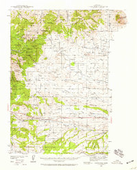 1941 Judith Peak1959 Print · USGSFergus County's high-altitude mining districts and military ruins are frozen in time just before the war. Trace the remnants of a gold boom at Maiden and Giltedge, or locate the Ruins of Fort Maginnis and several rural schoolhouses like Skaggs Sch.3 unique versions available
 - 1944 Map of Judith Peak
 1944 Judith Peak1944 Print · USGSThe Judith Mountains mining districts are shown in high detail during the early 1940s, from high peaks to the prairie rail lines. Genealogists and historians can locate the Ruins of Fort Maginnis, the Fort Maginnis Cem, and numerous mines like the Old Glory Mine.2 unique versions available
End of results
Showing maps 1-2 of 2
Top cities near Maiden
Frequently asked questions
- What are the different types of historical maps available for Maiden?
- What is the oldest map of Maiden?
- Where can I purchase historical maps of Maiden for my home or office?
- Where can I download high-res historical maps of Maiden?
- Are there historical topographic maps available for Maiden?
- Is there historical aerial imagery available for Maiden?
- Where are historical maps of Maiden sourced from?