1900s (20th Century) Maps of Pine Prairie, Montana
Explore 6 historic maps of Pine Prairie from the 1900s (20th Century). These maps offer a rare glimpse into what life looked like during the 1900s — showing old roads, neighborhoods, homes, and landmarks that have changed or disappeared over time.
Whether you're researching your family's past, planning a metal detecting trip, or studying how Pine Prairie's landscape evolved across the 1900s, these high-resolution maps are a powerful tool for exploring the history of this region.
- Focus on a specific era: All maps on this page are from the 1900s, giving you a focused view of this time period.
- See what’s changed: Compare century-old streets, trails, and buildings to today's modern landscape using overlays and satellite layers.
- Research with precision: Use these maps for genealogy, historical research, land use analysis, or educational projects.
- View, download, or print: Maps are fully viewable online in high resolution, and can be downloaded or printed for your own records.
Start exploring Pine Prairie's history through authentic maps from the 1900s. This is your window into the past.
Pine Prairie, MT maps
(6)- 1957 Map of Kalispell, 1967 Print
 1957 Kalispell1967 Print · USGSNorthwest Montana in the late fifties showcases a mountain landscape transitioning between wilderness and industry. Genealogists and researchers can trace the Great Northern rail corridor through Kalispell and Whitefish, or locate landmarks like the Montana Soldiers Home and Hungry Horse Reservoir.3 unique versions available
 - 1960 Map of Kalispell
 1960 Kalispell1960 Print · USGSNorthwest Montana in the late fifties is defined by the mountain corridors of the Great Northern Railway and the vast reaches of Glacier National Park. Researchers can trace the legacy of timber and mining towns like Libby, Rexford, and Whitefish, or locate landmarks such as the Snowshoe Mine.
 - 1961 Map of Kalispell
 1961 Kalispell1961 Print · USGSNorthwestern Montana at the start of the 1960s shows a landscape of timber-driven rail towns and the sprawling wild lands of Glacier National Park. Genealogists and historians can trace the route of the Great Northern through mountain passes or locate old settlements like Fortine, Trego, and Warland.
 - 1964 Map of Marion, 1967 Print
 1964 Marion1967 Print · USGSThe area around Marion and the shores of Little Bitterroot Lake are captured here in the mid-1960s. Genealogists and local historians can trace old homestead access via the Lower Lost Prairie Road and locate landmarks like Moore Springs and Granger Meadow.2 unique versions available
 - 1981 Map of Kalispell, 1982 Print
 1981 Kalispell1982 Print · USGSThe Flathead Valley in the early eighties shows a landscape defined by timber, tourism, and transit. Genealogists and historians can trace the growth of Evergreen, Bigfork, and Somers or locate early aviation landmarks like the Glacier Park Intl Airport.
 - 1994 Map of Marion, 1996 Print
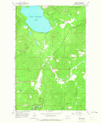
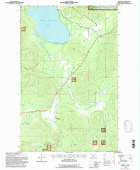 1994 Marion1996 Print · USGSMarion and the Salish Mountains are captured in the mid-1990s, showcasing a landscape of timbered peaks and vital waterways. Researchers can trace local landmarks like Little Bitterroot Lake, the small settlement of Pine Prairie, and the remote Moore Springs.
End of results
Showing maps 1-6 of 6
Frequently asked questions
- What are the different types of historical maps available for Pine Prairie?
- What is the oldest map of Pine Prairie?
- Where can I purchase historical maps of Pine Prairie for my home or office?
- Where can I download high-res historical maps of Pine Prairie?
- Are there historical topographic maps available for Pine Prairie?
- Is there historical aerial imagery available for Pine Prairie?
- Where are historical maps of Pine Prairie sourced from?