1940s Maps of Reserve, Fort Kipp District
Explore 2 historic maps of Reserve from the 1940s. These maps offer a rare glimpse into what life looked like during the 1940s — showing old roads, neighborhoods, homes, and landmarks that have changed or disappeared over time.
Whether you're researching your family's past, planning a metal detecting trip, or studying how Reserve's landscape evolved across the 1940s, these high-resolution maps are a powerful tool for exploring the history of this region.
- Focus on a specific era: All maps on this page are from the 1940s, giving you a focused view of this time period.
- See what’s changed: Compare century-old streets, trails, and buildings to today's modern landscape using overlays and satellite layers.
- Research with precision: Use these maps for genealogy, historical research, land use analysis, or educational projects.
- View, download, or print: Maps are fully viewable online in high resolution, and can be downloaded or printed for your own records.
Start exploring Reserve's history through authentic maps from the 1940s. This is your window into the past.
Reserve, Fort Kipp District maps
(2)- 1948 Map of Reserve, 1976 Print
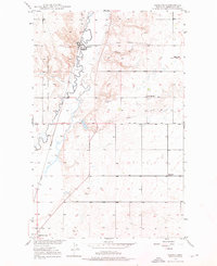 1948 Reserve1976 Print · USGSSheridan County's high plains are documented here in the late 1940s as the rail-side economy of Reserve thrived along the Great Northern line. Genealogists can trace early homestead-era landmarks like the Cem, Eden Valley Sch, and the local Coal Mine.2 unique versions available
 - 1949 Map of Reserve
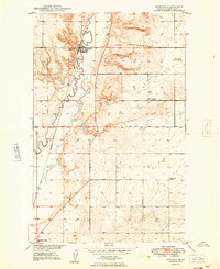 1949 Reserve1949 Print · USGSSheridan County and the northeastern corner of the Fort Peck Indian Reservation are captured here just after the war. Local historians can trace the Great Northern rail corridor through Reserve or locate school sites like Eden Valley Sch and Smith Sch (Aban'd).
End of results
Showing maps 1-2 of 2
Top cities near Reserve
Frequently asked questions
- What are the different types of historical maps available for Reserve?
- What is the oldest map of Reserve?
- Where can I purchase historical maps of Reserve for my home or office?
- Where can I download high-res historical maps of Reserve?
- Are there historical topographic maps available for Reserve?
- Is there historical aerial imagery available for Reserve?
- Where are historical maps of Reserve sourced from?