
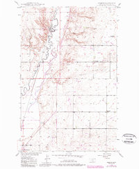
1948 Map of Reserve
USGS Topo · Published 1976About this map
Fort Peck Indian Reservation lands dominate the western portion of this mid-century landscape, where the Great Northern railroad tracks follow the meandering course of Muddy Creek. The settlement of Reserve serves as a local hub along the rail line, supported by a nearby Landing Field and early industrial activities like a Coal Mine. The eastern plains are dotted with the remnants of early twentieth-century education and community life, featuring Eden Valley Sch alongside two locations already marked as defunct by the late 1940s: Rose Hill Sch (Aban'd) and Smith Sch (Aban'd). This survey captures a moment of transition in Sheridan County, documenting the shift from small rural school districts toward more centralized patterns as the prairie landscape matured.
Find a feature on this map
17 named features on this map. Tap any name to fly to it.
Don’t see what you’re looking for? This feature index may not catch every label — zoom into the map to look around manually.
Map Details
Editions of this 1948 Reserve Map
2 editions found
Other maps of this area

1914 · Homestead
USGS Topo · 1:62,500

1947 · Capeneys Lake
USGS Topo · 1:24,000

1947 · Homestead
USGS Topo · 1:24,000

1948 · Homestead
USGS Topo · 1:24,000

1948 · Capeneys Lake
USGS Topo · 1:24,000

1948 · Reserve SE
USGS Topo · 1:24,000

1948 · Medicine Lake
USGS Topo · 1:24,000

1948 · Alkali Coulee
USGS Topo · 1:24,000

1948 · Antelope
USGS Topo · 1:24,000

1949 · Reserve SE
USGS Topo · 1:24,000