1948 Map of Antelope
USGS Topo · Published 1989About this map
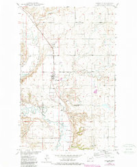
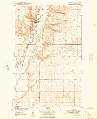
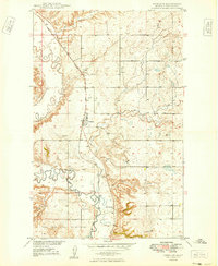
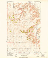
Antelope sits at the center of this Sheridan County landscape, where the Soo Line railroad runs alongside the meandering path of Big Muddy Creek. The terrain is defined by its drainage patterns, with Antelope Creek, Folsom Coulee, and Clarence Coulee carving through the prairie. To the south, the boundary of the Fort Peck Indian Reservation meets the settlement of McLaughlin, illustrating the overlap of tribal lands and early twentieth-century development. Evidence of local industry and community life appears in labels for a Gravel Pit, a Drill Hole, and a local Cem, reflecting the practical needs of this rural agricultural region. The map captures the area just as the Department of the Interior was focused on the development of the Missouri River Basin, documenting the essential water sources and transport links that sustained the high plains.
Find a feature on this map
14 named features on this map. Tap any name to fly to it.
Don’t see what you’re looking for? This feature index may not catch every label — zoom into the map to look around manually.
Map Details
Editions of this 1948 Antelope Map
This is the sole edition of this map. No revisions or reprints were ever made.
Other maps of this area
1948 · Reserve SE
USGS Topo · 1:24,000
1948 · Reserve
USGS Topo · 1:24,000
1948 · Alkali Coulee
USGS Topo · 1:24,000

1949 · Reserve SE
USGS Topo · 1:24,000
1949 · Reserve
USGS Topo · 1:24,000
1949 · Antelope
USGS Topo · 1:24,000

1949 · Alkali Coulee
USGS Topo · 1:24,000
1950 · Shippe Canyon
USGS Topo · 1:24,000

1954 · Wolf Point
USGS Topo · 1:250,000

1958 · Wolf Point
USGS Topo · 1:250,000