
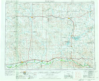
1954 Map of Wolf Point
USGS Topo · Published 1967About this map
The Missouri River corridor and the expansive Fort Peck Indian Reservation anchor this mid-century survey of Northeastern Montana and the North Dakota borderlands. The landscape is defined by the convergence of major waterways, including the winding Poplar River and Big Muddy Creek, which cut through the high plains toward the Missouri valley. This era reveals a robust agricultural and rail network, with the Great Northern railroad threading together critical hubs like Wolf Point, Poplar, and Culbertson along the southern river route.
Find a feature on this map
82 named features on this map. Tap any name to fly to it.
Don’t see what you’re looking for? This feature index may not catch every label — zoom into the map to look around manually.
Map Details
Editions of this 1954 Wolf Point Map
2 editions found
Other maps of this area

1909 · Glendive
USGS Topo · 1:250,000

1909 · Smoke Creek
USGS Topo · 1:62,500

1910 · Todd Lakes
USGS Topo · 1:62,500

1910 · Cuskers
USGS Topo · 1:62,500

1912 · Chelsea
USGS Topo · 1:62,500

1912 · Hay Creek
USGS Topo · 1:62,500

1912 · Poplar
USGS Topo · 1:62,500

1912 · Smoke Creek
USGS Topo · 1:62,500

1914 · Brockton
USGS Topo · 1:62,500

1914 · Homestead
USGS Topo · 1:62,500
Featured Places
- Wolf Point District, MT
- Wolf Point, Wolf Point District
- Plentywood, MT
- Scobey, MT
- Poplar, Poplar District