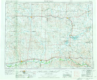
1954 Map of Wolf Point
USGS Topo · Published 1976About this map
The Missouri River winds along the southern edge of this mid-1970s landscape, defining the lower boundary of the Fort Peck Indian Reservation. This high-plains region is shaped by a dense network of coulees and creeks, including Nantennach Coulee and Wolf Creek, which drain toward the river systems. The Burlington Northern railroad serves as the primary corridor for human activity, connecting grain-handling towns like Poplar, Wolf Point, and Culbertson in the south, while a northern branch line ties together agricultural hubs such as Scobey, Plentywood, and Westby near the Canadian border. To the east, the Medicine Lake National Wildlife Refuge provides a significant biological contrast to the surrounding grid-patterned ranchlands, centered on the expansive waters of Medicine Lake. The map illustrates the specialized infrastructure of the Northern Plains, from the isolated rail station at Blair Station to the complex water systems like Big Muddy Creek.
Find a feature on this map
74 named features on this map. Tap any name to fly to it.
Don’t see what you’re looking for? This feature index may not catch every label — zoom into the map to look around manually.
Map Details
Editions of this 1954 Wolf Point Map
2 editions found

Other maps of this area

1909 · Glendive
USGS Topo · 1:250,000

1909 · Smoke Creek
USGS Topo · 1:62,500

1910 · Todd Lakes
USGS Topo · 1:62,500

1910 · Cuskers
USGS Topo · 1:62,500

1912 · Chelsea
USGS Topo · 1:62,500
1912 · Hay Creek
USGS Topo · 1:62,500

1912 · Poplar
USGS Topo · 1:62,500

1912 · Smoke Creek
USGS Topo · 1:62,500

1914 · Brockton
USGS Topo · 1:62,500

1914 · Homestead
USGS Topo · 1:62,500
Featured Places
- Wolf Point District, MT
- Wolf Point, Wolf Point District
- Plentywood, MT
- Scobey, MT
- Poplar, Poplar District