
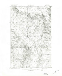
1909 Map of Smoke Creek
USGS Topo · Published 1964About this map
Fort Peck Indian Reservation dominates this landscape, showing the open-range character of northeastern Montana at the turn of the century. The terrain is defined by a sparse network of natural water sources and early settlement markers. The West Ranch stands as a primary landmark in a region where survival depended on proximity to features like Smoke Creek and various unnamed springs. The map illustrates a transitional period in land management, where the General Land Office surveyed the vast topography before more intensive modern development. To the southeast, Manning Lake and a larger unnamed Lake provide rare geographic focal points in a territory characterized by complex drainage patterns and isolated ranching outposts.
Find a feature on this map
7 named features on this map. Tap any name to fly to it.
Don’t see what you’re looking for? This feature index may not catch every label — zoom into the map to look around manually.
Map Details
Editions of this 1909 Smoke Creek Map
This is the sole edition of this map. No revisions or reprints were ever made.
Other maps of this area
1912 · Hay Creek
USGS Topo · 1:62,500

1912 · Poplar
USGS Topo · 1:62,500

1912 · Smoke Creek
USGS Topo · 1:62,500

1914 · Brockton
USGS Topo · 1:62,500

1914 · Homestead
USGS Topo · 1:62,500
1947 · Rocky Point
USGS Topo · 1:24,000

1948 · Rocky Point
USGS Topo · 1:24,000

1948 · Fort Kipp
USGS Topo · 1:24,000
1949 · Fort Kipp
USGS Topo · 1:24,000
1950 · Coyote Coulee
USGS Topo · 1:24,000
Featured Places
- Brockton District, MT
- Fort Kipp District, MT
- Anderson, Brockton District
- Biem, Brockton District
- Roosevelt County, MT