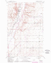
1948 Map of Reserve
USGS Topo · Published 1989About this map
Big Muddy Creek meanders through the heart of this Sheridan County landscape, where the eastern boundary of the Fort Peck Indian Reservation meets the agrarian plains of northeast Montana. Based on surveys from the late 1940s with late 20th-century revisions, the map documents the rural infrastructure supporting the community of Reserve. The drainage patterns of Otter Creek and Neiser Creek define the local topography, while scattered industrial sites like a Coal Mine and a Gravel Pit indicate the area's natural resource extraction history.
Find a feature on this map
19 named features on this map. Tap any name to fly to it.
Don’t see what you’re looking for? This feature index may not catch every label — zoom into the map to look around manually.
Map Details
Editions of this 1948 Reserve Map
2 editions found
Other maps of this area

1914 · Homestead
USGS Topo · 1:62,500

1947 · Capeneys Lake
USGS Topo · 1:24,000

1947 · Homestead
USGS Topo · 1:24,000

1948 · Homestead
USGS Topo · 1:24,000

1948 · Capeneys Lake
USGS Topo · 1:24,000

1948 · Reserve SE
USGS Topo · 1:24,000

1948 · Medicine Lake
USGS Topo · 1:24,000

1948 · Reserve
USGS Topo · 1:24,000

1948 · Alkali Coulee
USGS Topo · 1:24,000

1948 · Antelope
USGS Topo · 1:24,000