1900s (20th Century) Maps of Boulder, Montana
Explore 11 historic maps of Boulder from the 1900s (20th Century). These maps offer a rare glimpse into what life looked like during the 1900s — showing old roads, neighborhoods, homes, and landmarks that have changed or disappeared over time.
Whether you're researching your family's past, planning a metal detecting trip, or studying how Boulder's landscape evolved across the 1900s, these high-resolution maps are a powerful tool for exploring the history of this region.
- Focus on a specific era: All maps on this page are from the 1900s, giving you a focused view of this time period.
- See what’s changed: Compare century-old streets, trails, and buildings to today's modern landscape using overlays and satellite layers.
- Research with precision: Use these maps for genealogy, historical research, land use analysis, or educational projects.
- View, download, or print: Maps are fully viewable online in high resolution, and can be downloaded or printed for your own records.
Start exploring Boulder's history through authentic maps from the 1900s. This is your window into the past.
Boulder, MT maps
(11)- 1903 Map of Helena
 1903 Helena1903 Print · USGSMontana's mining heartland comes alive at the dawn of the new century, from the state capital to the copper-rich summits above the Silver Bow. Trace the early rail lines serving Marysville, locate the historic barracks of Ft. Harrison, and follow the mountain trails through Mullan Pass.4 unique versions available
 - 1947 Map of Butte, 1949 Print
 1947 Butte1949 Print · USGSWestern Montana at the peak of its rail-and-river era shows the vital connections between the mining and industrial centers of Butte and Helena. Researchers can trace the three major railroad lines serving mountain settlements like Garrison, Philipsburg, and Warm Springs.2 unique versions available
 - 1954 Map of Boulder, 1956 Print
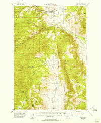 1954 Boulder1956 Print · USGSThe Boulder valley in the mid-fifties shows a landscape of mountain ranching and railway life. Genealogists and researchers can trace family holdings at the Keogh Ranch and Mc Cauley Ranch, or locate historic sites like the May Day Mine and Boulder Cem.4 unique versions available
 - 1958 Map of Butte
 1958 Butte1958 Print · USGSWestern Montana's mining and rail corridors are captured in the late fifties, from the urban bustle of the Copper King cities to high mountain passes. Researchers can trace the path of the Milwaukee St Paul and Pacific through Deer Lodge and locate remote outposts like Potomac Post Office.5 unique versions available
 - 1960 Map of Butte
 1960 Butte1960 Print · USGSWestern Montana at the dawn of the sixties is defined by its industrial mining hubs and the railroads that connect them. Genealogists and historians can trace the routes of the Milwaukee Road through Butte or locate smaller settlements like Southern Cross and Bearmouth.
 - 1962 Map of Butte
 1962 Butte1962 Print · USGSWestern Montana in the early sixties remains a landscape of industrial muscle and high-mountain passes. Trace the rail lines of the Northern Pacific through Deer Lodge and the mining history around Anaconda and Philipsburg.
 - 1985 Map of Boulder West, 1986 Print
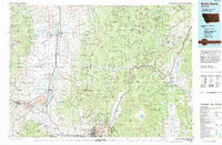
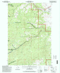
 1985 Boulder West1986 Print · USGSThe mountain terrain of Jefferson County comes into focus in the mid-1980s as it transitions from the Boulder valley into the forest. Researchers can trace the courses of the Boulder River and Little Boulder River or locate several Prospect sites and the high Doe Ridge.
 - 1985 Map of Boulder East, 1986 Print
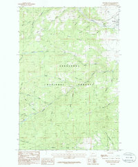
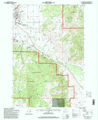
 1985 Boulder East1986 Print · USGSBoulder and its surrounding valley are captured in the mid-1980s as a community shaped by the river and the forest. Researchers can trace the town cemetery Cem, the landmark Boulder Hot Springs, and local mountain peaks like Bull Mountain.
 - 1994 Map of Butte North
 1994 Butte North1994 Print · USGSWestern Montana in the nineties was a landscape defined by ranching legacy and high-altitude mining. Genealogists and historians can trace institutional history at the Deer Lodge Prison Farm or locate old claims like the Saratoga Mine and Morning Glory Mine.
 - 1996 Map of Boulder West, 1998 Print
 1996 Boulder West1998 Print · USGSJefferson County mining and forest lands are captured here in the mid-1990s, centered on the rugged terrain west of Boulder. Local historians can trace early mineral claims at the May Day Mine or Springtime Mine and locate the Elder Creek Picnic Area.
 - 1996 Map of Boulder East, 1998 Print
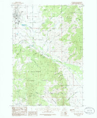
 1996 Boulder East1998 Print · USGSJefferson County's mountain-and-valley landscape is documented here in the mid-1990s, showcasing the development around Boulder and the surrounding forest. Genealogists and historians can locate the Cemetery, the Boulder River School & Hospital, and remote sites like Murphy Ranch.
End of results
Showing maps 1-11 of 11
Top cities near Boulder
Top neighborhoods of Boulder
Frequently asked questions
- What are the different types of historical maps available for Boulder?
- What is the oldest map of Boulder?
- Where can I purchase historical maps of Boulder for my home or office?
- Where can I download high-res historical maps of Boulder?
- Are there historical topographic maps available for Boulder?
- Is there historical aerial imagery available for Boulder?
- Where are historical maps of Boulder sourced from?