1950s Maps of Helena, Montana
Explore 4 historic maps of Helena from the 1950s. These maps offer a rare glimpse into what life looked like during the 1950s — showing old roads, neighborhoods, homes, and landmarks that have changed or disappeared over time.
Whether you're researching your family's past, planning a metal detecting trip, or studying how Helena's landscape evolved across the 1950s, these high-resolution maps are a powerful tool for exploring the history of this region.
- Focus on a specific era: All maps on this page are from the 1950s, giving you a focused view of this time period.
- See what’s changed: Compare century-old streets, trails, and buildings to today's modern landscape using overlays and satellite layers.
- Research with precision: Use these maps for genealogy, historical research, land use analysis, or educational projects.
- View, download, or print: Maps are fully viewable online in high resolution, and can be downloaded or printed for your own records.
Start exploring Helena's history through authentic maps from the 1950s. This is your window into the past.
Helena, MT maps
(4)- 1950 Map of East Helena, 1954 Print
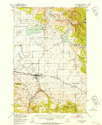 1950 East Helena1954 Print · USGSThe Missouri River valley near East Helena comes to life in the early fifties as a hub of rail transport and industrial mining. Genealogists and local historians can locate rural landmarks like Harmony School, St Anns Cem, and the Economy Mine.4 unique versions available
 - 1950 Map of Helena, 1954 Print
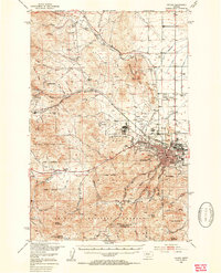 1950 Helena1954 Print · USGSThe Montana state capital and its mining-era outskirts are captured here just after the war, showing the city's growth alongside established military and medical sites. Researchers can trace the legacy of Unionville, locate the St Joseph Orphan Home, or explore the many gulches and mines that defined the early local economy.6 unique versions available
 - 1958 Map of Butte
 1958 Butte1958 Print · USGSWestern Montana's mining and rail corridors are captured in the late fifties, from the urban bustle of the Copper King cities to high mountain passes. Researchers can trace the path of the Milwaukee St Paul and Pacific through Deer Lodge and locate remote outposts like Potomac Post Office.5 unique versions available
 - 1958 Map of White Sulphur Springs, 1968 Print
 1958 White Sulphur Springs1968 Print · USGSCentral Montana in the late fifties was a landscape of high-country mining and newly formed reservoirs. You can trace the rail-and-river economy of the era through sites like Canyon Ferry Lake, the East Pacific Mine, and the historic Fort Logan.3 unique versions available
End of results
Showing maps 1-4 of 4
Top cities near Helena
Top neighborhoods of Helena
- Mansion District historical maps
- Prospect historical maps
- Last Chance Gulch historical maps
- Capitol Hill historical maps
- Custer historical maps
- Cedar Street historical maps
Frequently asked questions
- What are the different types of historical maps available for Helena?
- What is the oldest map of Helena?
- Where can I purchase historical maps of Helena for my home or office?
- Where can I download high-res historical maps of Helena?
- Are there historical topographic maps available for Helena?
- Is there historical aerial imagery available for Helena?
- Where are historical maps of Helena sourced from?