1900s (20th Century) Maps of Silver Star, Montana
Explore 9 historic maps of Silver Star from the 1900s (20th Century). These maps offer a rare glimpse into what life looked like during the 1900s — showing old roads, neighborhoods, homes, and landmarks that have changed or disappeared over time.
Whether you're researching your family's past, planning a metal detecting trip, or studying how Silver Star's landscape evolved across the 1900s, these high-resolution maps are a powerful tool for exploring the history of this region.
- Focus on a specific era: All maps on this page are from the 1900s, giving you a focused view of this time period.
- See what’s changed: Compare century-old streets, trails, and buildings to today's modern landscape using overlays and satellite layers.
- Research with precision: Use these maps for genealogy, historical research, land use analysis, or educational projects.
- View, download, or print: Maps are fully viewable online in high resolution, and can be downloaded or printed for your own records.
Start exploring Silver Star's history through authentic maps from the 1900s. This is your window into the past.
Silver Star, MT maps
(9)- 1955 Map of Dillon, 1978 Print
 1955 Dillon1978 Print · USGSSouthwest Montana at the dawn of the interstate era reveals a landscape of high-mountain ranching and historic mining camps. Trace the routes of the Union Pacific through Dillon and Armstead, or locate early settlements like Bannack and Wisdom.2 unique versions available
 - 1957 Map of Dillon
 1957 Dillon1957 Print · USGSSouthwest Montana and Idaho in the mid-fifties reveal a high-country landscape of mountain ranges and ranching valleys. Genealogists can trace family holdings and rail stops along the Union Pacific Railroad, from Dillon to historic Virginia City and Twin Bridges.
 - 1958 Map of Dillon
 1958 Dillon1958 Print · USGSSouthwestern Montana during the late fifties reveals a high-country landscape defined by the Continental Divide and a legacy of mountain mining. Genealogists and historians can trace rail lines like the Union Pacific or locate early industrial sites including the Hecla Mine and Ermont Mine.
 - 1960 Map of Twin Bridges, 1963 Print
 1960 Twin Bridges1963 Print · USGSMadison County in the early sixties shows a landscape defined by the meeting of four major rivers and the legacy of the mining boom. Genealogists and historians can trace family-named sites like Pogliano Ranch, the Pageville Sch, and dozens of lode mines including the Shamrock Mine.3 unique versions available
 - 1962 Map of Dillon
 1962 Dillon1962 Print · USGSSouthwest Montana in the early sixties is defined by its high mountain ranges and the winding rivers that carved its settlement patterns. Trace the rail routes of the Union Pacific through Dillon or locate mining activity near Butte and Argenta.
 - 1965 Map of Dillon
 1965 Dillon1965 Print · USGSSouthwest Montana in the mid-1960s is defined by its rugged river valleys and high mountain passes along the Continental Divide. Researchers can trace the path of the Union Pacific through Dillon and Armstead, or locate early mining activity near Melrose and Wise River.
 - 1975 Map of Butte South
 1975 Butte South1975 Print · USGSIn the mid-1970s, the mountainous terrain south of Butte was a hub of mining and rail activity. You can trace the Burlington Northern line through historic settlements like Melrose, Twin Bridges, and Whitehall, or locate family-named mines including Watseca Mine and Hecla Mines.
 - 1989 Map of Silver Star
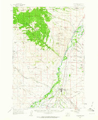
 1989 Silver Star1989 Print · USGSMadison County mining history and river valley irrigation are on full display in the late eighties. Researchers can trace historic extraction sites like the Keystone Mine and Clipper Mine or locate family-named landmarks such as Bayers Lane and Ironrod Bridge.
 - 1996 Map of Silver Star, 1998 Print
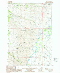
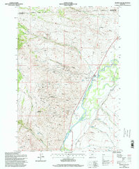 1996 Silver Star1998 Print · USGSSilver Star and the Jefferson River valley are shown in the late twentieth century, when high-altitude mining still shaped the Madison County landscape. Metal detectorists and local historians can trace numerous workings like the Keystone and Stella mines or locate the old Cemetery and Ironrod Bridge.
End of results
Showing maps 1-9 of 9
Top cities near Silver Star
- Butte historical maps
- Whitehall historical maps
- Sheridan historical maps
- Twin Bridges historical maps
- Donald historical maps
Frequently asked questions
- What are the different types of historical maps available for Silver Star?
- What is the oldest map of Silver Star?
- Where can I purchase historical maps of Silver Star for my home or office?
- Where can I download high-res historical maps of Silver Star?
- Are there historical topographic maps available for Silver Star?
- Is there historical aerial imagery available for Silver Star?
- Where are historical maps of Silver Star sourced from?