1900s (20th Century) Maps of Varney, Montana
Explore 9 historic maps of Varney from the 1900s (20th Century). These maps offer a rare glimpse into what life looked like during the 1900s — showing old roads, neighborhoods, homes, and landmarks that have changed or disappeared over time.
Whether you're researching your family's past, planning a metal detecting trip, or studying how Varney's landscape evolved across the 1900s, these high-resolution maps are a powerful tool for exploring the history of this region.
- Focus on a specific era: All maps on this page are from the 1900s, giving you a focused view of this time period.
- See what’s changed: Compare century-old streets, trails, and buildings to today's modern landscape using overlays and satellite layers.
- Research with precision: Use these maps for genealogy, historical research, land use analysis, or educational projects.
- View, download, or print: Maps are fully viewable online in high resolution, and can be downloaded or printed for your own records.
Start exploring Varney's history through authentic maps from the 1900s. This is your window into the past.
Varney, MT maps
(9)- 1947 Map of Bozeman, 1948 Print
 1947 Bozeman1948 Print · USGSBozeman and the surrounding mountain ranges are captured here just after the war, showing the vital rail and river networks of southwestern Montana. Genealogists and historians can trace routes to early settlements like Virginia City, Gallatin Gateway, and the mountain community of Jardine.
 - 1948 Map of Bozeman, 1951 Print
 1948 Bozeman1951 Print · USGSSouthern Montana in the late 1940s is shown as a high-country crossroads of rail lines and river headwaters. Genealogists and historians can trace old town sites like Virginia City and McLeod alongside the Northern Pacific and Milwaukee Road railroads.
 - 1949 Map of Varney, 1952 Print
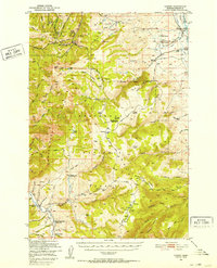 1949 Varney1952 Print · USGSMadison County ranching and high-altitude mining define this post-war landscape as it transitioned into modern land management. Researchers can trace historic mineral claims like the Marietta Mine and Summit Mine or locate family ranch holdings including the Rankin Ranch and Hudson Ranch.3 unique versions available
 - 1955 Map of Bozeman
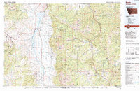
 1955 Bozeman1955 Print · USGSBozeman and the upper Missouri River headwaters are captured here during the mid-fifties, showing the vital rail and river networks of southwestern Montana. Local historians can trace the routes of the Northern Pacific railroad through Livingston and locate smaller settlements like Trident, Anceney, and Jardine.
 - 1958 Map of Bozeman, 1968 Print
 1958 Bozeman1968 Print · USGSThe Gallatin and Madison River valleys are captured here in the late fifties, showing the region's transition into a modern mountain hub. Genealogists and historians can trace the paths of the Northern Pacific RR, locate the Anceney School, and see the early layout of Bozeman.3 unique versions available
 - 1965 Map of Bozeman
 1965 Bozeman1965 Print · USGSSouthwestern Montana's river valleys and mountain ranges appear in detail during the early 1960s. Genealogists and historians can trace rail-era settlements like Trident, locate the Anceney School, and see the early footprint of Montana State College.
 - 1988 Map of Varney, 1989 Print
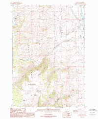 1988 Varney1989 Print · USGSThe Madison River valley and Gravelly Range are captured in the late eighties, documenting the area's transition from riverbed to forest. Researchers can trace land use through the Ennis National Fish Hatchery, the Varney settlement, and Axolotl Lake.
 - 1989 Map of Ennis, 1990 Print
 1989 Ennis1990 Print · USGSMadison County ranching and the rise of mountain tourism define this region during the 1980s. Genealogists and historians can trace the development of Ennis, find historic mining sites like the Missouri Mine, or locate the settlements at Virginia City and McAllister.
 - 1997 Map of Varney, 2002 Print
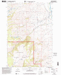 1997 Varney2002 Print · USGSThe Madison River valley and Gravelly Range come alive in the late 1990s as this survey documents ranching outposts and high-country waters. Researchers can locate family landmarks like Kent Ranch and Woodward Place alongside the Ennis National Fish Hatchery.
End of results
Showing maps 1-9 of 9
Top cities near Varney
Frequently asked questions
- What are the different types of historical maps available for Varney?
- What is the oldest map of Varney?
- Where can I purchase historical maps of Varney for my home or office?
- Where can I download high-res historical maps of Varney?
- Are there historical topographic maps available for Varney?
- Is there historical aerial imagery available for Varney?
- Where are historical maps of Varney sourced from?