1950s Maps of Ford Place, Montana
Explore 2 historic maps of Ford Place from the 1950s. These maps offer a rare glimpse into what life looked like during the 1950s — showing old roads, neighborhoods, homes, and landmarks that have changed or disappeared over time.
Whether you're researching your family's past, planning a metal detecting trip, or studying how Ford Place's landscape evolved across the 1950s, these high-resolution maps are a powerful tool for exploring the history of this region.
- Focus on a specific era: All maps on this page are from the 1950s, giving you a focused view of this time period.
- See what’s changed: Compare century-old streets, trails, and buildings to today's modern landscape using overlays and satellite layers.
- Research with precision: Use these maps for genealogy, historical research, land use analysis, or educational projects.
- View, download, or print: Maps are fully viewable online in high resolution, and can be downloaded or printed for your own records.
Start exploring Ford Place's history through authentic maps from the 1950s. This is your window into the past.
Ford Place, MT maps
(2)- 1951 Map of Ringling, 1953 Print
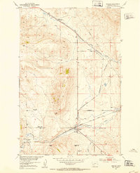 1951 Ringling1953 Print · USGSMeagher County ranching and rail travel intersect in the early fifties as the Milwaukee Road follows the creek through this Montana landscape. Genealogists can trace family holdings at the Adkison Ranch and Higgins Ranch or locate the Moss Agate stage site.3 unique versions available
 - 1958 Map of White Sulphur Springs, 1968 Print
 1958 White Sulphur Springs1968 Print · USGSCentral Montana in the late fifties was a landscape of high-country mining and newly formed reservoirs. You can trace the rail-and-river economy of the era through sites like Canyon Ferry Lake, the East Pacific Mine, and the historic Fort Logan.3 unique versions available
End of results
Showing maps 1-2 of 2
Frequently asked questions
- What are the different types of historical maps available for Ford Place?
- What is the oldest map of Ford Place?
- Where can I purchase historical maps of Ford Place for my home or office?
- Where can I download high-res historical maps of Ford Place?
- Are there historical topographic maps available for Ford Place?
- Is there historical aerial imagery available for Ford Place?
- Where are historical maps of Ford Place sourced from?