1990s Maps of BN Plaza, Missoula
Explore 2 historic maps of BN Plaza from the 1990s. These maps offer a rare glimpse into what life looked like during the 1990s — showing old roads, neighborhoods, homes, and landmarks that have changed or disappeared over time.
Whether you're researching your family's past, planning a metal detecting trip, or studying how BN Plaza's landscape evolved across the 1990s, these high-resolution maps are a powerful tool for exploring the history of this region.
- Focus on a specific era: All maps on this page are from the 1990s, giving you a focused view of this time period.
- See what’s changed: Compare century-old streets, trails, and buildings to today's modern landscape using overlays and satellite layers.
- Research with precision: Use these maps for genealogy, historical research, land use analysis, or educational projects.
- View, download, or print: Maps are fully viewable online in high resolution, and can be downloaded or printed for your own records.
Start exploring BN Plaza's history through authentic maps from the 1990s. This is your window into the past.
BN Plaza, Missoula maps
(2)- 1999 Map of Southeast Missoula, 2003 Print
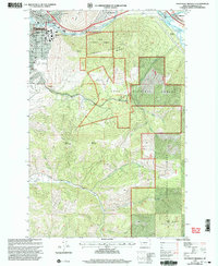 1999 Southeast Missoula2003 Print · USGSThe eastern edge of Missoula and the lower Clark Fork valley are captured here at the turn of the millennium. Researchers can trace the university campus, locate Milltown Dam, and find early local landmarks like Prescott Sch and Mount Sentinel.
 - 1999 Map of Northeast Missoula, 2003 Print
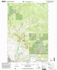 1999 Northeast Missoula2003 Print · USGSMissoula’s northeastern corridor at the close of the century shows a unique mix of wild forest boundaries and riverfront growth. Researchers can trace historic landmarks like St Mary Cem, the Marshall Ski Area, and the early settlement at East Missoula.
End of results
Showing maps 1-2 of 2
Frequently asked questions
- What are the different types of historical maps available for BN Plaza?
- What is the oldest map of BN Plaza?
- Where can I purchase historical maps of BN Plaza for my home or office?
- Where can I download high-res historical maps of BN Plaza?
- Are there historical topographic maps available for BN Plaza?
- Is there historical aerial imagery available for BN Plaza?
- Where are historical maps of BN Plaza sourced from?