1980s Maps of Content, Montana
Explore 2 historic maps of Content from the 1980s. These maps offer a rare glimpse into what life looked like during the 1980s — showing old roads, neighborhoods, homes, and landmarks that have changed or disappeared over time.
Whether you're researching your family's past, planning a metal detecting trip, or studying how Content's landscape evolved across the 1980s, these high-resolution maps are a powerful tool for exploring the history of this region.
- Focus on a specific era: All maps on this page are from the 1980s, giving you a focused view of this time period.
- See what’s changed: Compare century-old streets, trails, and buildings to today's modern landscape using overlays and satellite layers.
- Research with precision: Use these maps for genealogy, historical research, land use analysis, or educational projects.
- View, download, or print: Maps are fully viewable online in high resolution, and can be downloaded or printed for your own records.
Start exploring Content's history through authentic maps from the 1980s. This is your window into the past.
Content, MT maps
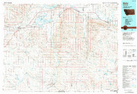
(2)- 1984 Map of Content
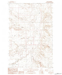 1984 Content1984 Print · USGSPhillips County in the late seventies and early eighties is shown here as a landscape of wide-open prairie and intricate coulee systems. Genealogists and researchers can trace the vicinity of Content and the sprawling Sun Prairie Flats or locate landmarks like Beaver Creek and Twin Lake Coulee.
 - 1984 Map of Malta
 1984 Malta1984 Print · USGSNorthern Montana's river and rail corridor is meticulously detailed in the mid-1980s, centered on the Milk River and Malta. Researchers can trace the Burlington Northern line through historic stops like Hinsdale, Ashfield, and Beaverton.
End of results
Showing maps 1-2 of 2
Frequently asked questions
- What are the different types of historical maps available for Content?
- What is the oldest map of Content?
- Where can I purchase historical maps of Content for my home or office?
- Where can I download high-res historical maps of Content?
- Are there historical topographic maps available for Content?
- Is there historical aerial imagery available for Content?
- Where are historical maps of Content sourced from?