1960s Maps of Dodson, Montana
Explore 2 historic maps of Dodson from the 1960s. These maps offer a rare glimpse into what life looked like during the 1960s — showing old roads, neighborhoods, homes, and landmarks that have changed or disappeared over time.
Whether you're researching your family's past, planning a metal detecting trip, or studying how Dodson's landscape evolved across the 1960s, these high-resolution maps are a powerful tool for exploring the history of this region.
- Focus on a specific era: All maps on this page are from the 1960s, giving you a focused view of this time period.
- See what’s changed: Compare century-old streets, trails, and buildings to today's modern landscape using overlays and satellite layers.
- Research with precision: Use these maps for genealogy, historical research, land use analysis, or educational projects.
- View, download, or print: Maps are fully viewable online in high resolution, and can be downloaded or printed for your own records.
Start exploring Dodson's history through authentic maps from the 1960s. This is your window into the past.
Dodson, MT maps
(2)- 1964 Map of Dodson, 1967 Print
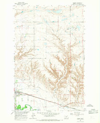 1964 Dodson1967 Print · USGSThe town of Dodson and the Phillips County ranchlands are captured here in the mid-1960s as a vital rail and river corridor. Genealogists and historians can trace the Great Northern railroad, the Milk River irrigation canals, and landmarks like the Hillside Cem.
 - 1964 Map of Dodson Dam, 1968 Print
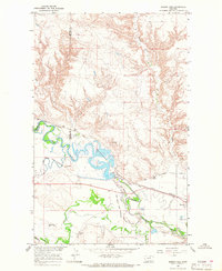 1964 Dodson Dam1968 Print · USGSPhillips County in the mid-1960s was a hub for Milk River irrigation and Great Northern rail traffic. Researchers can trace the Fort Belknap Indian Reservation Boundary, locate the Cem at Graveyard Hill, and follow the Dodson North Canal.
End of results
Showing maps 1-2 of 2
Frequently asked questions
- What are the different types of historical maps available for Dodson?
- What is the oldest map of Dodson?
- Where can I purchase historical maps of Dodson for my home or office?
- Where can I download high-res historical maps of Dodson?
- Are there historical topographic maps available for Dodson?
- Is there historical aerial imagery available for Dodson?
- Where are historical maps of Dodson sourced from?