1980s Maps of East Malta Hutterite Colony, Montana
Explore 2 historic maps of East Malta Hutterite Colony from the 1980s. These maps offer a rare glimpse into what life looked like during the 1980s — showing old roads, neighborhoods, homes, and landmarks that have changed or disappeared over time.
Whether you're researching your family's past, planning a metal detecting trip, or studying how East Malta Hutterite Colony's landscape evolved across the 1980s, these high-resolution maps are a powerful tool for exploring the history of this region.
- Focus on a specific era: All maps on this page are from the 1980s, giving you a focused view of this time period.
- See what’s changed: Compare century-old streets, trails, and buildings to today's modern landscape using overlays and satellite layers.
- Research with precision: Use these maps for genealogy, historical research, land use analysis, or educational projects.
- View, download, or print: Maps are fully viewable online in high resolution, and can be downloaded or printed for your own records.
Start exploring East Malta Hutterite Colony's history through authentic maps from the 1980s. This is your window into the past.
East Malta Hutterite Colony, MT maps
(2)- 1984 Map of Pinks
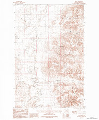 1984 Pinks1984 Print · USGSPhillips County was a landscape of managed water and sharp terrain contrasts during the 1980s. Researchers can trace irrigation infrastructure like the Bowdoin Canal and locate family-named landmarks including Gilbertson Coulee and Pinks.
 - 1984 Map of Malta
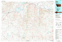 1984 Malta1984 Print · USGSNorthern Montana's river and rail corridor is meticulously detailed in the mid-1980s, centered on the Milk River and Malta. Researchers can trace the Burlington Northern line through historic stops like Hinsdale, Ashfield, and Beaverton.
End of results
Showing maps 1-2 of 2
Frequently asked questions
- What are the different types of historical maps available for East Malta Hutterite Colony?
- What is the oldest map of East Malta Hutterite Colony?
- Where can I purchase historical maps of East Malta Hutterite Colony for my home or office?
- Where can I download high-res historical maps of East Malta Hutterite Colony?
- Are there historical topographic maps available for East Malta Hutterite Colony?
- Is there historical aerial imagery available for East Malta Hutterite Colony?
- Where are historical maps of East Malta Hutterite Colony sourced from?