1980s Maps of Valier, Montana
Explore 3 historic maps of Valier from the 1980s. These maps offer a rare glimpse into what life looked like during the 1980s — showing old roads, neighborhoods, homes, and landmarks that have changed or disappeared over time.
Whether you're researching your family's past, planning a metal detecting trip, or studying how Valier's landscape evolved across the 1980s, these high-resolution maps are a powerful tool for exploring the history of this region.
- Focus on a specific era: All maps on this page are from the 1980s, giving you a focused view of this time period.
- See what’s changed: Compare century-old streets, trails, and buildings to today's modern landscape using overlays and satellite layers.
- Research with precision: Use these maps for genealogy, historical research, land use analysis, or educational projects.
- View, download, or print: Maps are fully viewable online in high resolution, and can be downloaded or printed for your own records.
Start exploring Valier's history through authentic maps from the 1980s. This is your window into the past.
Valier, MT maps
(3)- 1984 Map of Valier
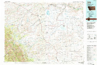 1984 Valier1984 Print · USGSNorthwestern Montana in the mid-1980s reveals a unique landscape of Hutterite agricultural colonies and high mountain wilderness. Genealogists and historians can trace the irrigation networks and rail stops from Valier to Birch Creek Colony and the Kellogg Mine.
 - 1985 Map of Valier West, 1986 Print
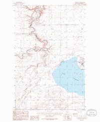 1985 Valier West1986 Print · USGSPondera County at the mid-eighties shows a landscape defined by the intersection of the Blackfeet Indian Reservation and large-scale irrigation projects. Researchers can trace the water network from Lake Frances through the A N 2 Canal to the town of Valier.
 - 1985 Map of Valier East, 1986 Print
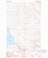 1985 Valier East1986 Print · USGSThe Pondera County plains come to life in the mid-eighties as the town of Valier stands beside the broad waters of Lake Frances. Researchers can trace the region's infrastructure through features like the A N 2 Canal, the settlement of Williams, and the Valier Municipal Airport.
End of results
Showing maps 1-3 of 3
Frequently asked questions
- What are the different types of historical maps available for Valier?
- What is the oldest map of Valier?
- Where can I purchase historical maps of Valier for my home or office?
- Where can I download high-res historical maps of Valier?
- Are there historical topographic maps available for Valier?
- Is there historical aerial imagery available for Valier?
- Where are historical maps of Valier sourced from?