1950s Maps of Roosevelt County, Montana
Explore 8 historic maps of Roosevelt County from the 1950s. These maps offer a rare glimpse into what life looked like during the 1950s — showing old roads, neighborhoods, homes, and landmarks that have changed or disappeared over time.
Whether you're researching your family's past, planning a metal detecting trip, or studying how Roosevelt County's landscape evolved across the 1950s, these high-resolution maps are a powerful tool for exploring the history of this region.
- Focus on a specific era: All maps on this page are from the 1950s, giving you a focused view of this time period.
- See what’s changed: Compare century-old streets, trails, and buildings to today's modern landscape using overlays and satellite layers.
- Research with precision: Use these maps for genealogy, historical research, land use analysis, or educational projects.
- View, download, or print: Maps are fully viewable online in high resolution, and can be downloaded or printed for your own records.
Start exploring Roosevelt County's history through authentic maps from the 1950s. This is your window into the past.
Roosevelt County, MT maps
(8)- 1950 Map of Johnson Lake
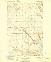
 1950 Johnson Lake1950 Print · USGSRoosevelt County at the mid-century shows a landscape of reservation lands and wildlife conservation areas. Researchers can trace the winding course of Muddy Creek and locate features like the Medicine Lake National Wildlife Refuge, Johnson Lake, and early Gravel Pits.
 - 1950 Map of Coyote Coulee, 1952 Print
 1950 Coyote Coulee1952 Print · USGSRoosevelt County ranching and reservation life are captured here in the early fifties during the Missouri River Basin development era. Genealogists and historians can trace the remote Schnitzler Ranch or the winding paths of Coyote Coulee and Smoke Creek.2 unique versions available
 - 1950 Map of Calais, 1952 Print
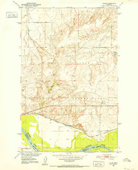 1950 Calais1952 Print · USGSNortheastern Montana's river valley and high plains come into focus at mid-century, where the reservation meets the winding Missouri. Genealogists and historians can trace the Great Northern rail line through Calais or locate the Alton Mine and Bertino Res.2 unique versions available
 - 1954 Map of Glendive, 1967 Print
 1954 Glendive1967 Print · USGSEastern Montana at mid-century shows a landscape of river-valley commerce and remote prairie ranching. Researchers can trace the legacy of rural education and transport through sites like Prairie Elk School, the Great Northern rail lines, and Circle.2 unique versions available
 - 1954 Map of Wolf Point, 1967 Print
 1954 Wolf Point1967 Print · USGSNortheastern Montana and the North Dakota borderlands are shown here in the mid-fifties, dominated by the Missouri River and the Fort Peck Indian Reservation. Genealogists and historians can trace the Great Northern rail line through river towns like Poplar and Culbertson or locate northern border outposts like the U S Custom Office at Raymond.2 unique versions available
 - 1957 Map of Glendive
 1957 Glendive1957 Print · USGSEastern Montana in the mid-1950s is defined by its deep river valleys and a sprawling network of rural school districts. You can trace the path of the Great Northern railroad and locate vanished local landmarks like Breezy Flat School and Newton Junction.
 - 1958 Map of Wolf Point
 1958 Wolf Point1958 Print · USGSNortheastern Montana is shown during the mid-fifties, featuring the extensive Fort Peck Indian Reservation and the Missouri River valley. Researchers can trace the Great Northern railroad through Wolf Point or locate sites like Slab Crossing and the Coal Mine near Medicine Lake.
 - 1958 Map of Glendive
 1958 Glendive1958 Print · USGSEastern Montana and the North Dakota borderlands come alive in the late fifties, showing the agricultural heart of the Yellowstone valley. Trace the legacy of rural education through Kimmel School and Ridgelawn School or locate rail hubs in Glendive and Sidney.
End of results
Showing maps 1-8 of 8
Top cities of Roosevelt County
- Wolf Point District historical maps
- Poplar District historical maps
- Culbertson historical maps
- Brockton District historical maps
- Froid historical maps
- Bainville historical maps
Frequently asked questions
- What are the different types of historical maps available for Roosevelt County?
- What is the oldest map of Roosevelt County?
- Where can I purchase historical maps of Roosevelt County for my home or office?
- Where can I download high-res historical maps of Roosevelt County?
- Are there historical topographic maps available for Roosevelt County?
- Is there historical aerial imagery available for Roosevelt County?
- Where are historical maps of Roosevelt County sourced from?