Old Maps of Lonepine, Montana for Metal Detecting
Plan your next treasure hunt with 7 historic maps of Lonepine. Find old homesites, ghost towns, trails, and gathering spots that may be lost to time — perfect for identifying promising metal detecting locations.
- Locate forgotten sites: Uncover places like long-lost settlements, abandoned rail lines, or gathering spots.
- Plan better hunts: Use map overlays combined with LiDAR or satellite views to narrow in on historically rich areas.
- Made for detectorists: Thousands of hobbyists use these maps to discover relics, coins, and hidden history.
Use these historic maps to boost your research and find new opportunities beneath the surface of Lonepine.
Lonepine, MT maps
(7)- 1956 Map of Wallace, 1966 Print
 1956 Wallace1966 Print · USGSWestern Montana and the Idaho panhandle meet in this mid-century survey of the Bitterroot and Cabinet Mountains. Genealogists and historians can trace the rail-and-river economy through the Northern Pacific line and settlements like Thompson Falls or St. Ignatius.3 unique versions available
 - 1960 Map of Wallace
 1960 Wallace1960 Print · USGSNorthwestern Montana and the Idaho panhandle are captured in the late fifties, showing the vast Flathead Indian Reservation and the mining districts of the Bitterroot Range. Researchers can trace the rail lines of the Northern Pacific or locate early sites like the Morning Mine and the National Bison Range.
 - 1964 Map of Lonepine, 1967 Print
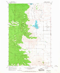 1964 Lonepine1967 Print · USGSSanders County ranching and timber lands meet in the mid-1960s along the Flathead Indian Reservation Boundary. Researchers can locate family landmarks near Lonepine, including Murray Memorial Cem and the Community Hall.
 - 1980 Map of Polson, 1982 Print
 1980 Polson1982 Print · USGSThe Flathead Indian Reservation and its surrounding timberlands are captured here in the early eighties. Genealogists and historians can trace the development of Polson, locate remote sites like the Flathead Mine, and follow the Burlington Northern rail line through Pablo and Ronan.
 - 1989 Map of Lonepine
 1989 Lonepine1989 Print · USGSLonepine and the eastern edge of the Bitterroot mountains are documented here in the late eighties during a period of established reservation agriculture. Genealogists and local researchers can trace family landmarks like the Murray Memorial Cem, Community Hall, and the extensive Camas Canal irrigation system.
 - 1999 Map of Lonepine, 2003 Print
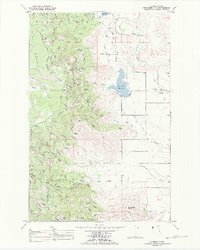
 1999 Lonepine2003 Print · USGSLonepine and the surrounding Sanders County landscape appear in the late nineties at the intersection of tribal and national forest lands. Local historians can locate the Community Hall, Murray Memorial Cem, and the waters of Dry Fork Reservoir.
 - 2024 Map of Lonepine, 2024 Print
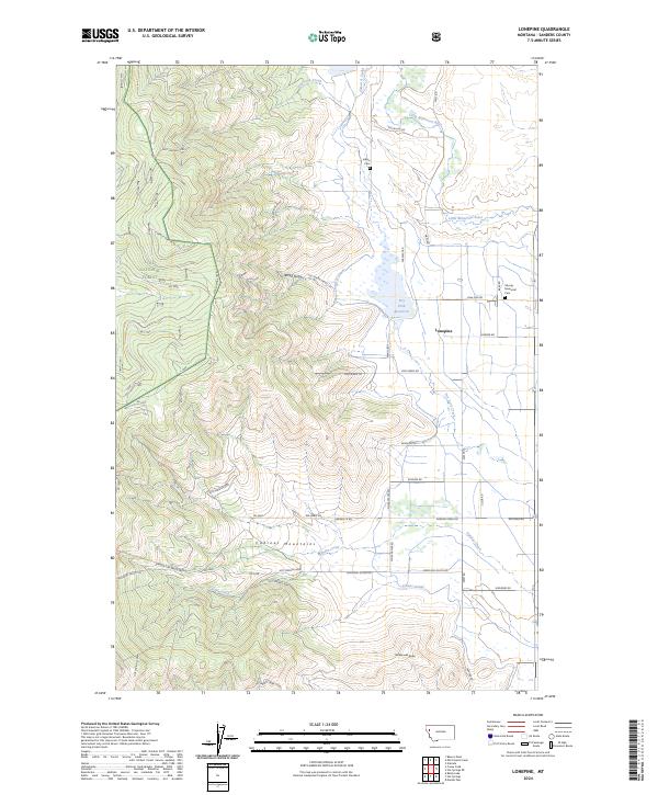 2024 Lonepine2024 Print · USGSLonepine and the eastern foothills of the Cabinet Mountains are shown here in modern detail, illustrating the intersection of national forest land and irrigated valley ranching. Researchers can locate Murray Memorial Cem, trace the vital Camas Canal network, and find landmarks like Rattlesnake Butte.
End of results
Showing maps 1-7 of 7
Top cities near Lonepine
Frequently asked questions
- What are the different types of historical maps available for Lonepine?
- What is the oldest map of Lonepine?
- Where can I purchase historical maps of Lonepine for my home or office?
- Where can I download high-res historical maps of Lonepine?
- Are there historical topographic maps available for Lonepine?
- Is there historical aerial imagery available for Lonepine?
- Where are historical maps of Lonepine sourced from?